The Atlas
Alexandria in twelve historical maps
A working catalogue of historical maps of Alexandria, drawn from the Library of Congress Geography & Map Division, the LOC Sanborn collection, and the City of Alexandria’s own historic-maps page. Every entry below is in the public domain. Click through to the source for the high-resolution scan.
The set traces Alexandria’s cartographic record across two and a half centuries: from a sixteen-year-old George Washington’s surveyor’s plat for the Fairfax County court, to the patriotic bird’s-eye lithograph Charles Magnus printed for occupied Union troops, to the block-by-block Sanborn fire-insurance atlases that recorded every smokehouse, stable, and warehouse in the industrial city.
Plan of the Land Whereon Stands the Town of Alexandria
Surveyor's plat of the 60-acre original townsite, drafted by 16-year-old George Washington for the Fairfax County court. Predates the formal establishment of Alexandria by a year and shows the bluff above the Potomac before the streets were laid out.
One of the earliest surviving cartographic depictions of the site that would become Alexandria. Washington was apprenticing under Lord Fairfax.
LOC, G3884.A3 1748 .W3 VaultA Plan of Alexandria, Now Belhaven
Plan showing the new town with its grid of seven streets and the original 84 building lots. The name "Belhaven" — for Scottish patriot Lord Belhaven — was briefly used in parallel with "Alexandria" in the first months after the General Assembly's founding act.
LOC, G3884.A4 1763.W4 VaultAlexandria
Mid-eighteenth-century town plan extending the 1749 grid as Alexandria grew westward. Fairfax County's surveyor George West, brother to original surveyor John West Jr., produced this updated plan as the town approached its first major expansion.
LOC, G3884.A4 1763.W4 VaultCamp à Alexandrie
Amérique Campagne — Camp à Alexandrie
French military encampment map drafted on the return march of Rochambeau's army after the victory at Yorktown. The camp at Alexandria was one of a string the French laid out between Williamsburg and Boston — surveyed with characteristic precision and preserved in Rochambeau's papers.
LOC, G1201.S3 R65 1782 Vault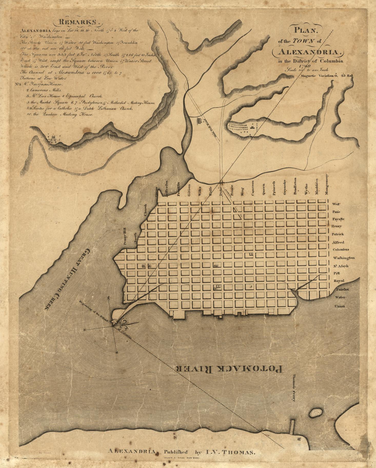
Plan of the Town of Alexandria in the District of Columbia
The benchmark plan of post-Revolutionary Alexandria, drafted by Col. George Gilpin (Washington's pallbearer at Mount Vernon) at the moment Alexandria became part of the new Federal District. Shows the dramatically expanded waterfront — created by dredging the Potomac and using the spoil to fill in new lots — and Alexandria at the height of its commercial life as the lone port of entry on the river.
Drawn as pen-and-ink and blue wash on tracing linen; Dr. Joseph M. Toner later traced this from Gilpin's original.
View at Library of Congress → I. Thomas (engraver)U.S. Forts and Batteries near Alexandria, Va. — September 1862
Detailed Civil War-era map of the Defenses of Washington south of the Potomac, drawn by Pvt. Robert Knox Sneden of the 40th New York. Shows Fort Lyon (the largest of the Alexandria forts), Fort Ward, Fort Williams, the Manassas Gap RR, and the corduroyed military roads connecting them. Sneden later spent thirteen months in Confederate prisons.
LOC, Library of Congress / Virginia Historical Society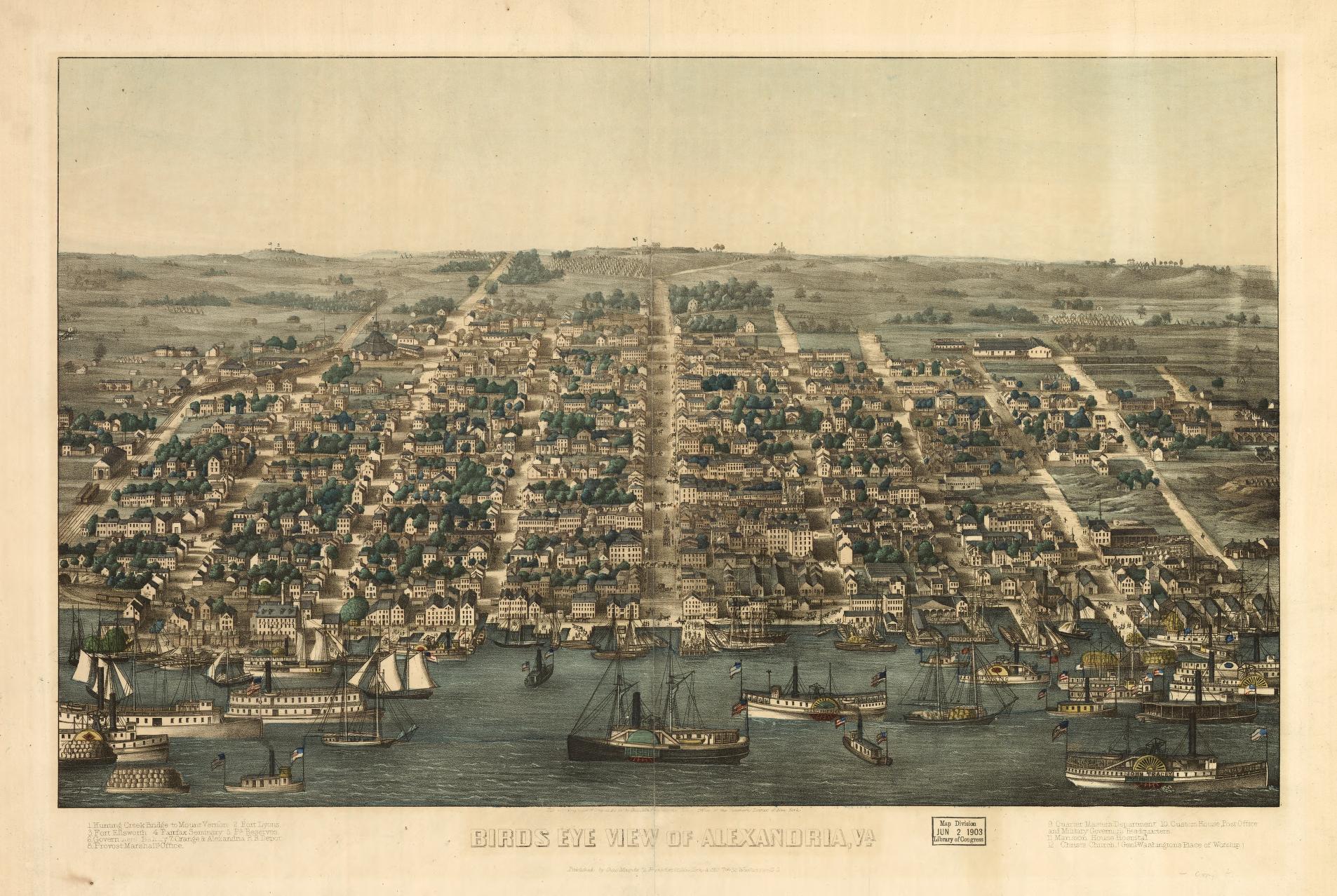
Bird's-Eye View of Alexandria, Va.
Wartime panoramic lithograph showing occupied Alexandria from above the Potomac, with the federal supply quartermasters' depots, the Soldiers' Rest barracks, the rail yards, and a flotilla of Union transports lining the wharves. Magnus published several variants — this is the canonical view used on patriotic stationery and song sheets sold to Union troops.
Magnus also produced No. 2.B and No. 5.C variants held by George Mason University. The 1864 "Camp Convalescent" view is a related companion piece.
View at Library of Congress → Charles Magnus, New York and Washington, D.C.City Atlas of Alexandria, Va.
Block-by-block plate atlas of Alexandria showing every parcel, every property owner's name, and the footprint of every standing building. The Hopkins atlases of the 1870s are the high-water mark of urban cadastral mapping — each color block on the plates encodes building material (brick = pink, frame = yellow, stone = blue).
Source pendingG.M. Hopkins, Philadelphia
Atlas of Fifteen Miles around Washington (Fairfax & Alexandria sheets)
Regional atlas of the Washington hinterland; the Alexandria and Fairfax sheets show post-bellum farmsteads with each property labeled by owner, the network of pikes and turnpikes radiating from Alexandria, and the alignment of the Orange & Alexandria and the Alexandria, Loudoun & Hampshire railroads.
View at Library of Congress → G.M. Hopkins, Philadelphia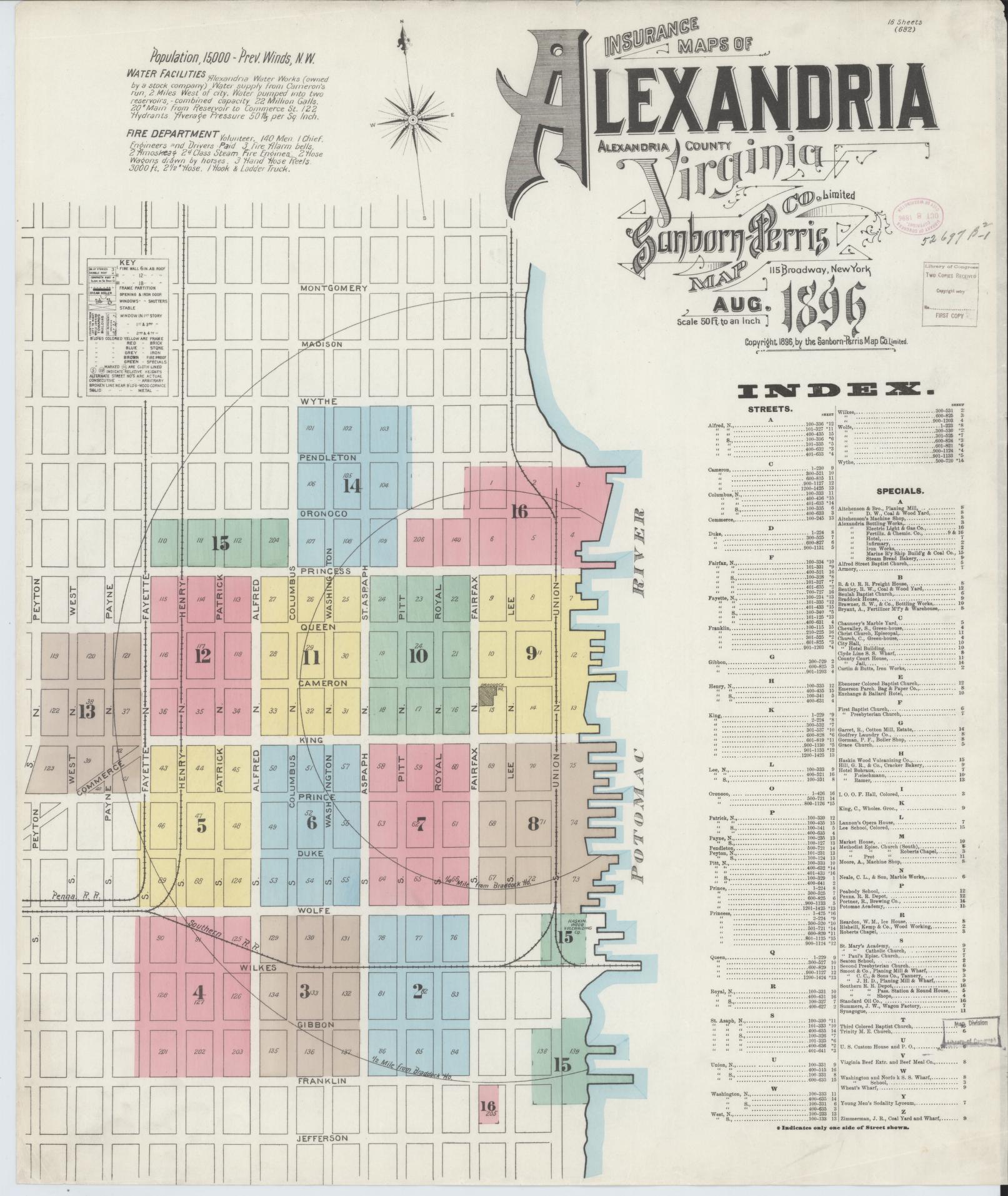
Sanborn Fire Insurance Atlas of Alexandria — July 1885
Eleven-sheet large-scale atlas drawn for fire-insurance underwriters, detailing every structure in Alexandria with building material, number of stories, occupancy, and water supply. The Sanborn plates are the most exhaustive record of any nineteenth-century American city's built fabric — every store, stable, smokehouse, privy, and hose reel is rendered to scale.
View at Library of Congress → Sanborn Map & Publishing Co., New YorkSanborn Fire Insurance Atlas of Alexandria — July 1891
Fifteen-sheet update reflecting six years of post-1885 building campaigns, particularly along King Street's commercial spine and the streetcar-fed expansion of West End. Fire damage from the early 1880s — including the burnt remains of warehouses along the wharf — is annotated.
Source pendingSanborn Fire Insurance Atlas of Alexandria — November 1907
Twenty-five-sheet edition documenting the fully industrialized Alexandria of the early twentieth century — the Robert Portner Brewing complex, the Belle Pre Bottle Works, the Mutual Ice Co., the Smoot Lumber yards, and the city's web of brick warehouses along the RF&P and Southern rail spurs.
Source pending