
Places on file
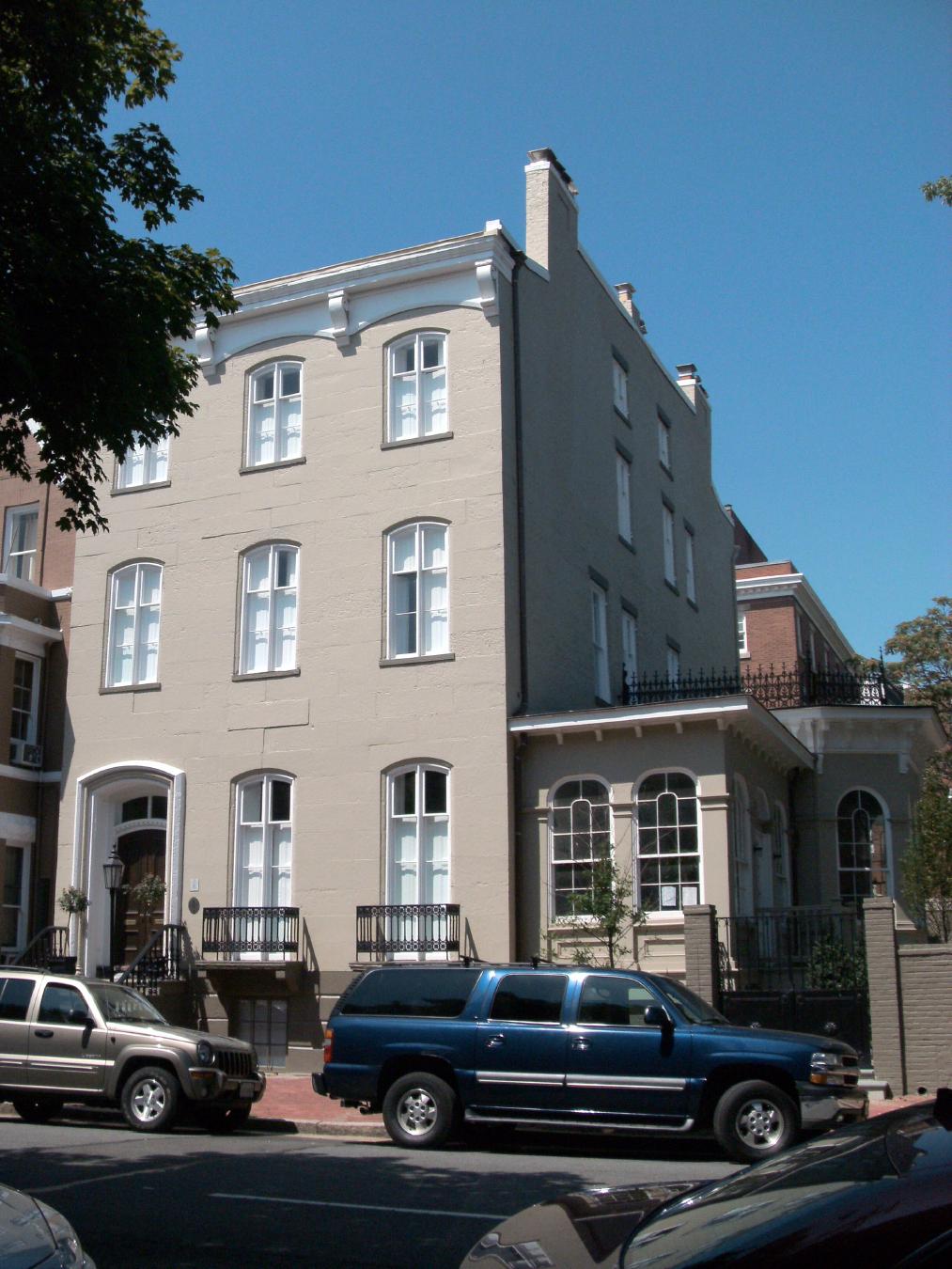
The original uploader was Ser Amantio di Nicolao at English Wikipedia . · via Wikimedia Commons · CC BY 3.0 105 South Fairfax Street
Apothecary operated 1792-1933 by the Stabler and Leadbeater families; designated a National Historic Landmark in 2021. NRHP-listed 1982.
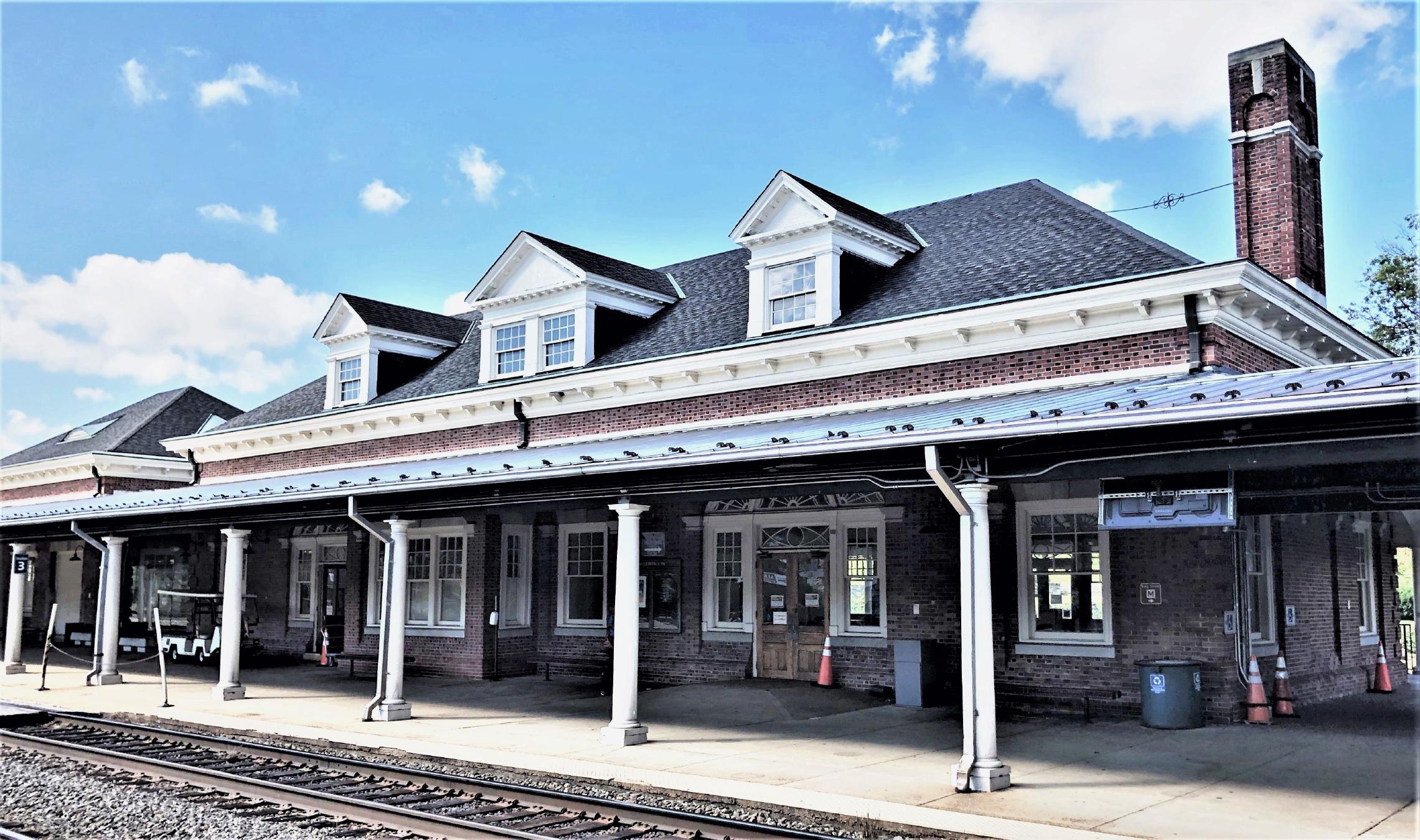
Beyond My Ken · via Wikimedia Commons · CC BY-SA 4.0 110 Callahan Drive
1905 railway terminal at the foot of King Street, currently serving Amtrak, VRE, and Washington Metro Blue/Yellow lines. NRHP-listed 2013.
Bruce Andersen from Washington, DC · via Wikimedia Commons · CC BY-SA 2.0 1220 Wilkes Street
Sandstone boundary marker placed 1791 to mark the southwest corner of the original District of Columbia diamond. NRHP-listed 1991.
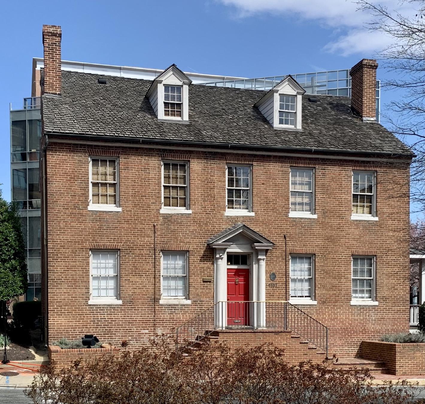
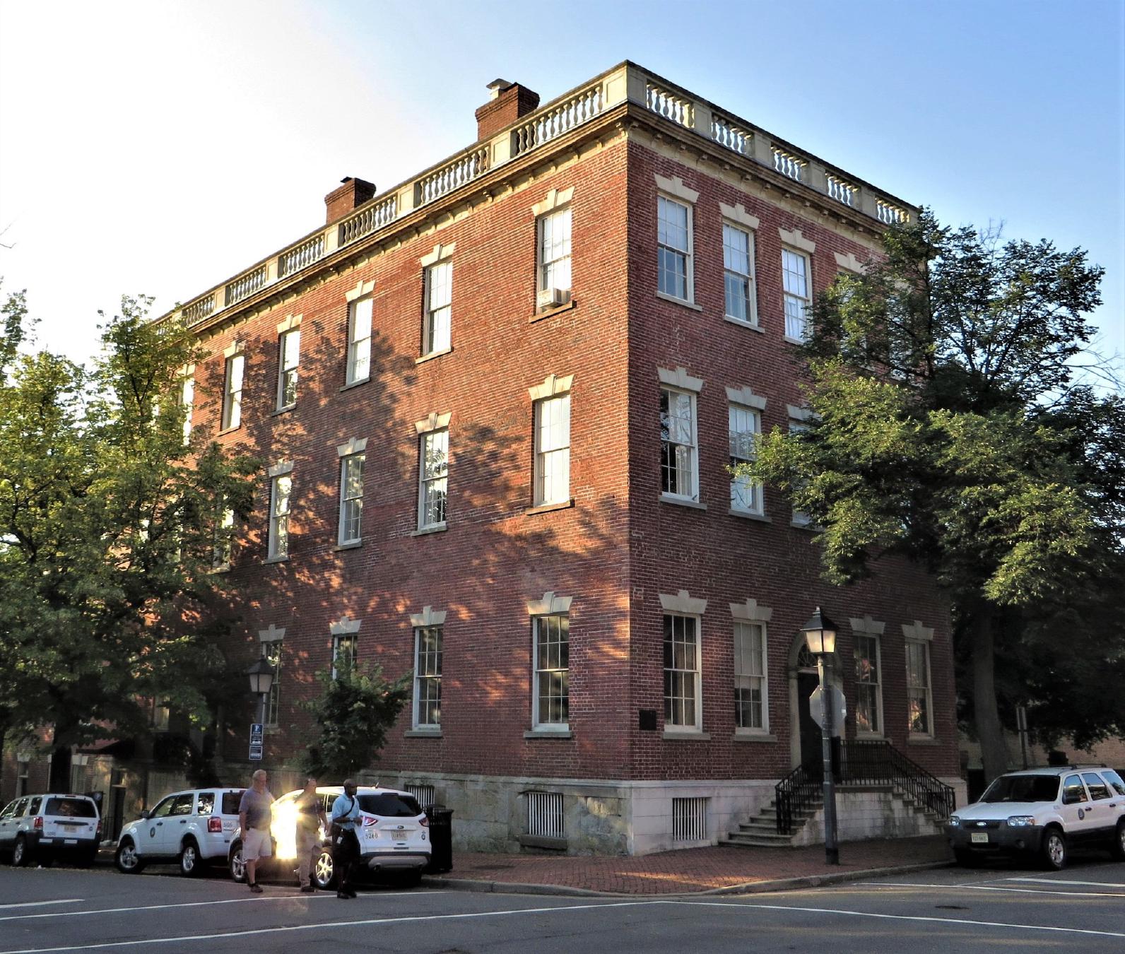
APK · via Wikimedia Commons · CC BY-SA 4.0 1707 Duke Street
Antebellum jail compound operated by slave trader Joseph Bruin from the 1840s through emancipation. NRHP-listed 2000.
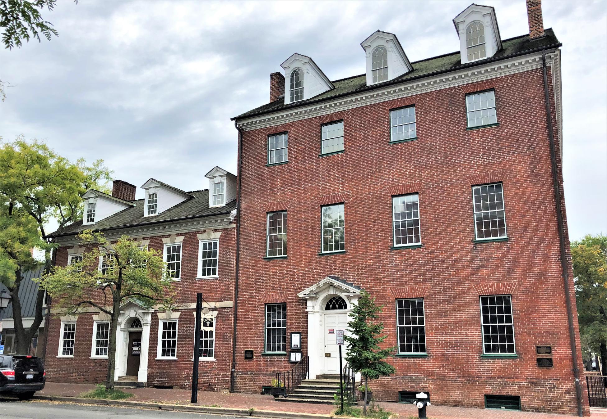
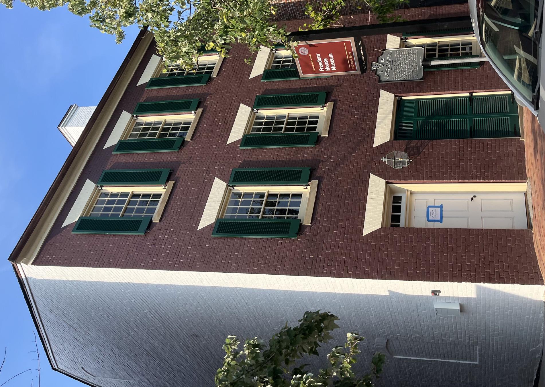
AgnosticPreachersKid at en.wikipedia · via Wikimedia Commons · CC BY-SA 3.0 201 Prince Street
Late-19th-century commercial building at the corner of Prince and Lee streets, an early local example of small-town bank architecture. NRHP-listed 1980.
Beyond My Ken · via Wikimedia Commons · CC BY-SA 4.0 206 North Pitt Street
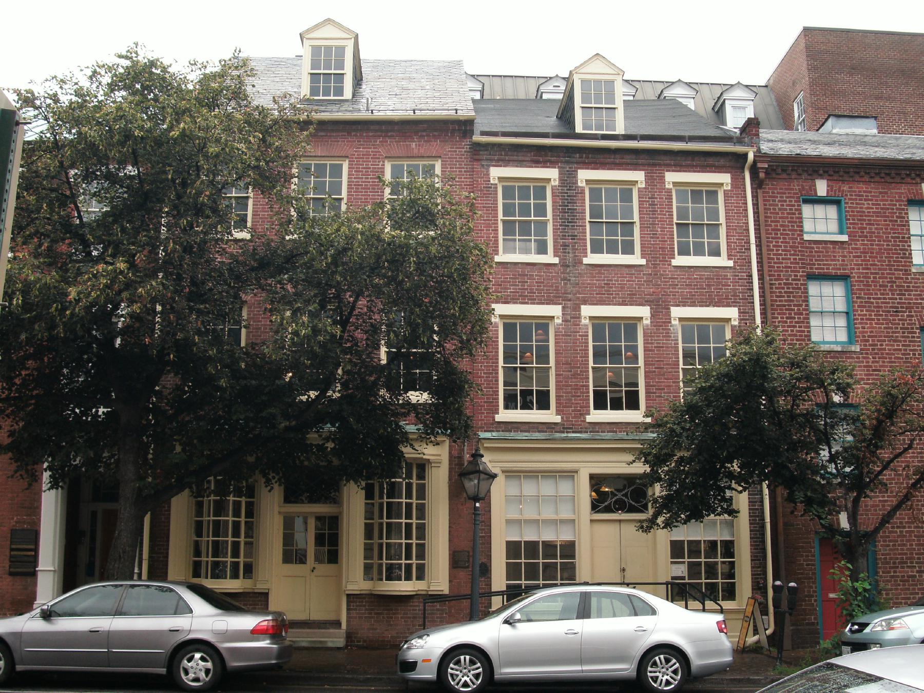
Three brick rowhouses built ca. 1849 by Moses Hepburn, a free Black property owner and one of antebellum Alexandria's wealthiest African Americans. …
Ser Amantio di Nicolao at en.wikipedia · via Wikimedia Commons · CC BY 3.0 207 Prince Street
Brick townhouse built ca. 1763 in the colonial heart of Alexandria. NRHP-listed 1991.
Farragutful · via Wikimedia Commons · CC BY-SA 4.0 228 South Pitt Street
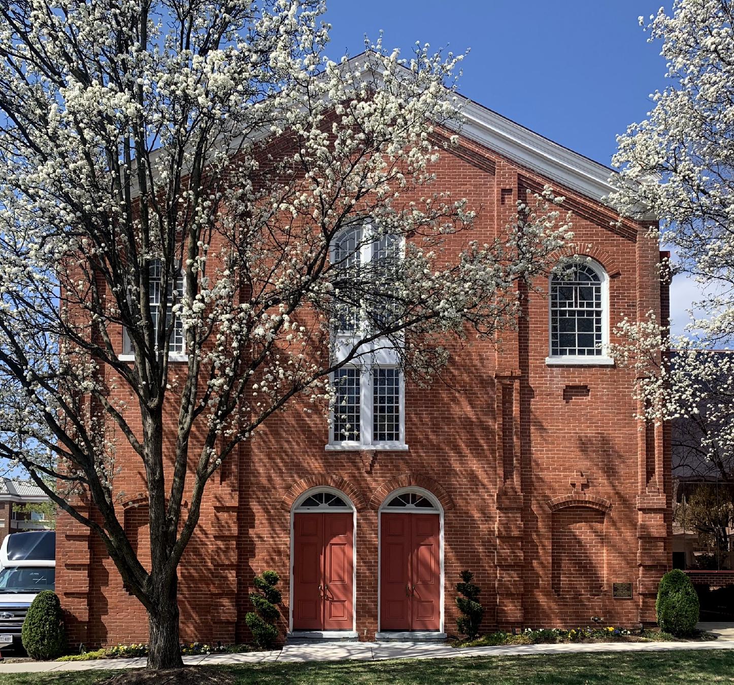
Federal-Greek Revival 1817 sanctuary, the second oldest Episcopal congregation in Alexandria after Christ Church. NRHP-listed 1985.
Hero image · pending 2605 King Street
Single-family residence on the upper / western stretch of King Street in the corridor annexed from Alexandria County in 1915. Possibly associated by family …
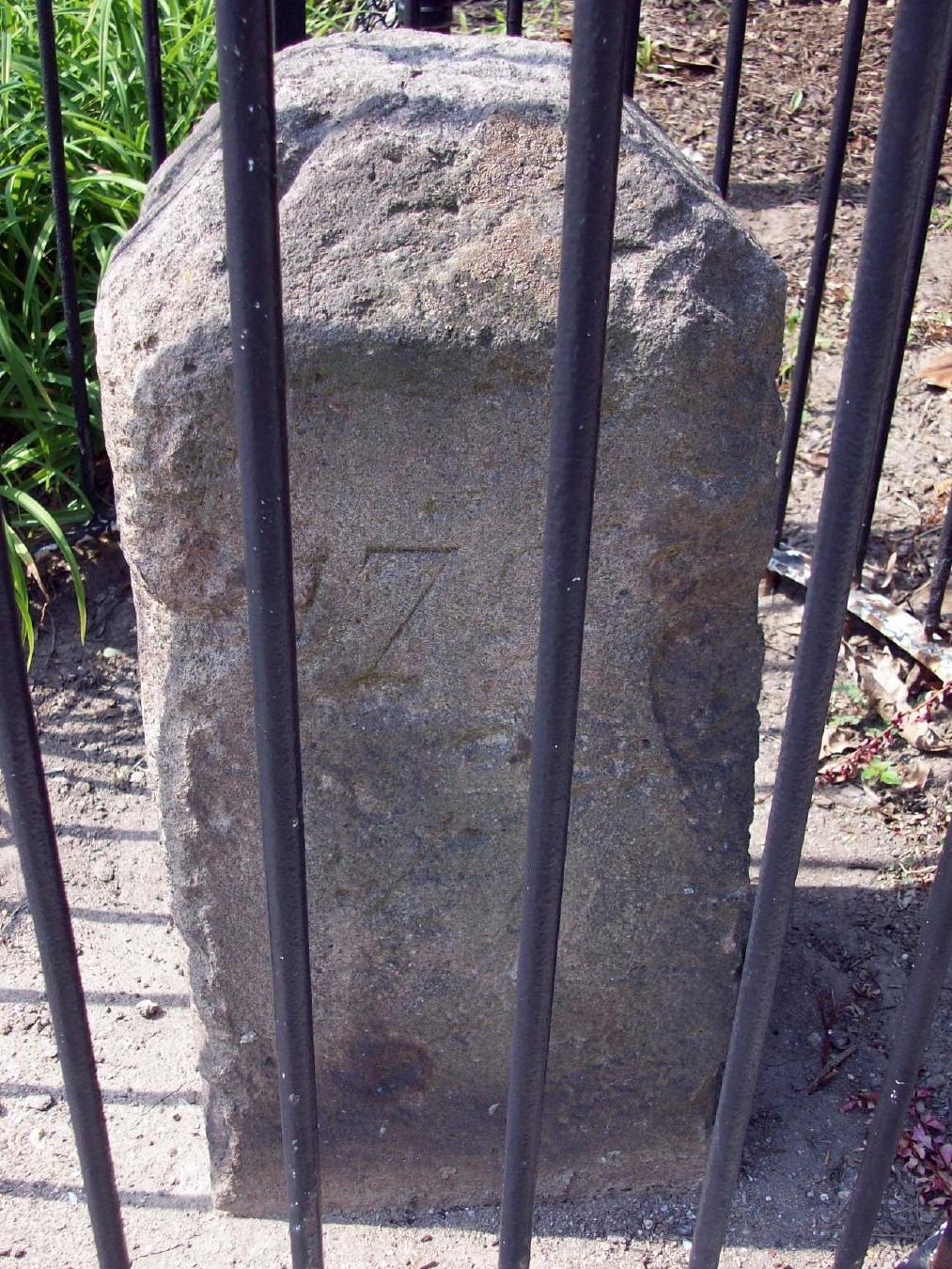
Bruce Andersen from Washington, DC · via Wikimedia Commons · CC BY-SA 2.0 2952 King Street
Third of the original DC southwestern boundary stones, placed 1791-1792. NRHP-listed 1991.
APK · via Wikimedia Commons · CC BY-SA 4.0 313 South Alfred Street
One of the oldest African-American Baptist congregations in the United States, founded in 1803; present sanctuary erected 1855. NRHP-listed 2004.
Hero image · pending 320 South Washington Street
Founded in 1863 by formerly enslaved Black congregants; one of the earliest independent Black Baptist churches in the South. NRHP-listed 2004.
Hero image · pending 400 Fontaine Street
Lower School (JK through grade 5) of St. Stephen's & St. Agnes School, on Fontaine Street in Seminary Hill. Originally a campus of St. Agnes School for …
Hero image · pending 404 South Royal Street
Mid-19th-century residence of George Lewis Seaton, a free Black master carpenter who served in the Virginia House of Delegates during Reconstruction. …
Hero image · pending 411 South Columbus Street
Late-19th-century Black fraternal lodge, part of Alexandria's African-American civic infrastructure during Jim Crow. NRHP-listed 2004.
Hero image · pending 413 Prince Street
Early-19th-century brick building used as the Bank of Potomac's executive office and as a Virginia governor's residence. NRHP-listed 2025.
Hero image · pending 4195 West Braddock Road
African-American cemetery established 1885 on land adjacent to Fort Ward, used by descendants of the freedmen's community known as The Fort. NRHP-listed …
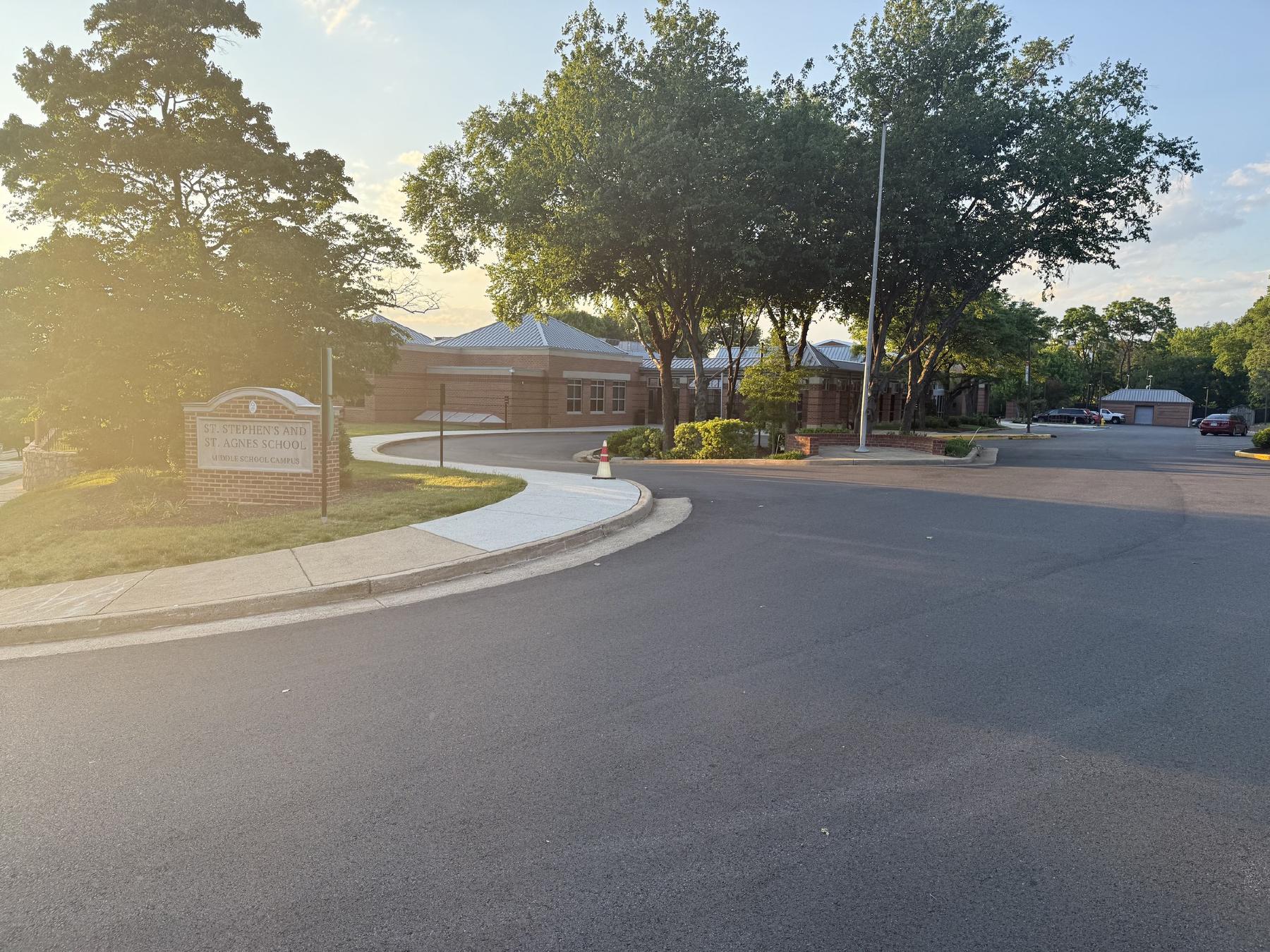
St. Stephen's and St. Agnes Middle School Campus on West Braddock Road at sunrise — the entrance sign and the brick academic buildings beyond, back-lit by golden-hour light. © KingSt.com, 2024 4401 West Braddock Road
Middle School (grades 6–8) of St. Stephen's & St. Agnes since the late 1990s, on the West Braddock Road campus that previously housed Ascension Academy …
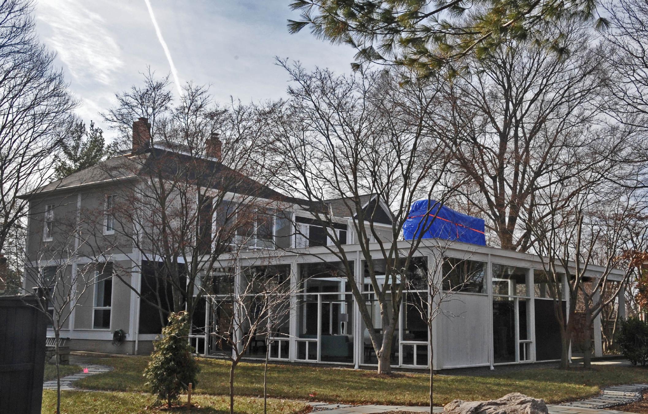
Jerrye & Roy Klotz, MD · via Wikimedia Commons · CC BY-SA 3.0 510 North Quaker Lane
Mid-century modern residence designed by architect Charles M. Goodman, who pioneered modernist housing in the Washington region. NRHP-listed 2013.
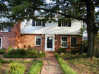
Quarterczar ( talk ) · via Wikimedia Commons · Public domain 514 Crown View Drive
Suburban Alexandria home of Gerald R. Ford and family during his vice-presidency and at the time of his ascension to the presidency in 1974. NRHP-listed 1985.
Hero image · pending 606 South Washington Street
Mid-19th-century chapel, part of Alexandria's antebellum African Methodist Episcopal congregation. NRHP-listed 2004.
Bruce Andersen from Washington, DC · via Wikimedia Commons · CC BY-SA 2.0 7 Russell Road
Second of the original DC southwestern boundary stones, placed 1791-1792. NRHP-listed 1991.
Hero image · pending 712 Prince Street
Federal-style 1820s townhouse later occupied by mayor and judge Henry Daingerfield's family. NRHP-listed 2019.
Ser Amantio de Nicalao · via Wikimedia Commons · CC BY-SA 3.0 811 Prince Street
Italianate residence built 1854 by merchant John Bayne; later occupied by the Fowle family of shipbuilders. NRHP-listed 1986.
Hero image · pending 814 Duke Street
Townhouse associated with Dr. Albert Johnson, a 19th-century African-American physician in Alexandria. NRHP-listed 2004.
Hero image · pending 816 Vicar Lane
Cul-de-sac suburban house off Quaker Lane that was the residence of Wernher von Braun from his 1970 NASA retirement until his death at Alexandria Hospital on …
AgnosticPreachersKid at en.wikipedia · via Wikimedia Commons · CC BY-SA 3.0 Alexandria Historic District
Old and Historic Alexandria District, the colonial-through-antebellum core of the city, listed on the National Register in 1966.
Hero image · pending Beauregard Street
Mid-century residential community off Beauregard Street in West End Alexandria, near the Mark Center / I-395 federal-office cluster. Representative of the West …
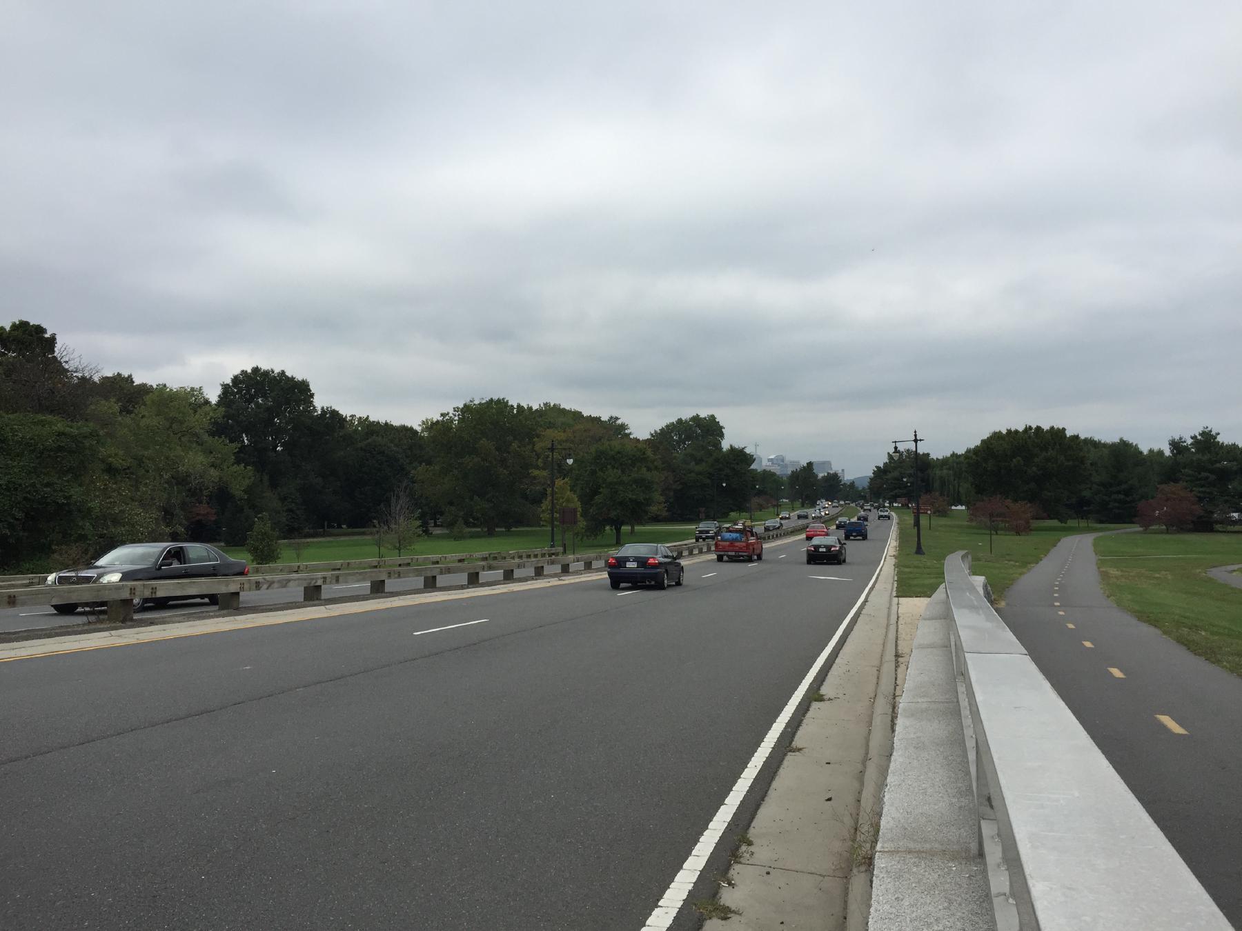
Famartin · via Wikimedia Commons · CC BY-SA 4.0 George Washington Memorial Parkway
Scenic parkway completed 1932 from Memorial Bridge to Mount Vernon, the first federally constructed parkway commemorating Washington's bicentennial. …
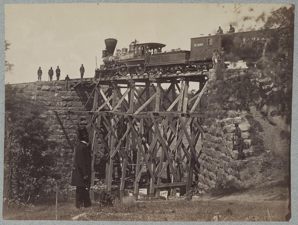
Bridge on Orange & Alexandria Railroad · Library of Congress, Prints & Photographs Division · http://www.loc.gov/item/2012649966/ Jamieson Avenue at Hooff's Run
1851 stone arch railroad bridge, in continuous use since the eve of the Civil War. NRHP-listed 2003.
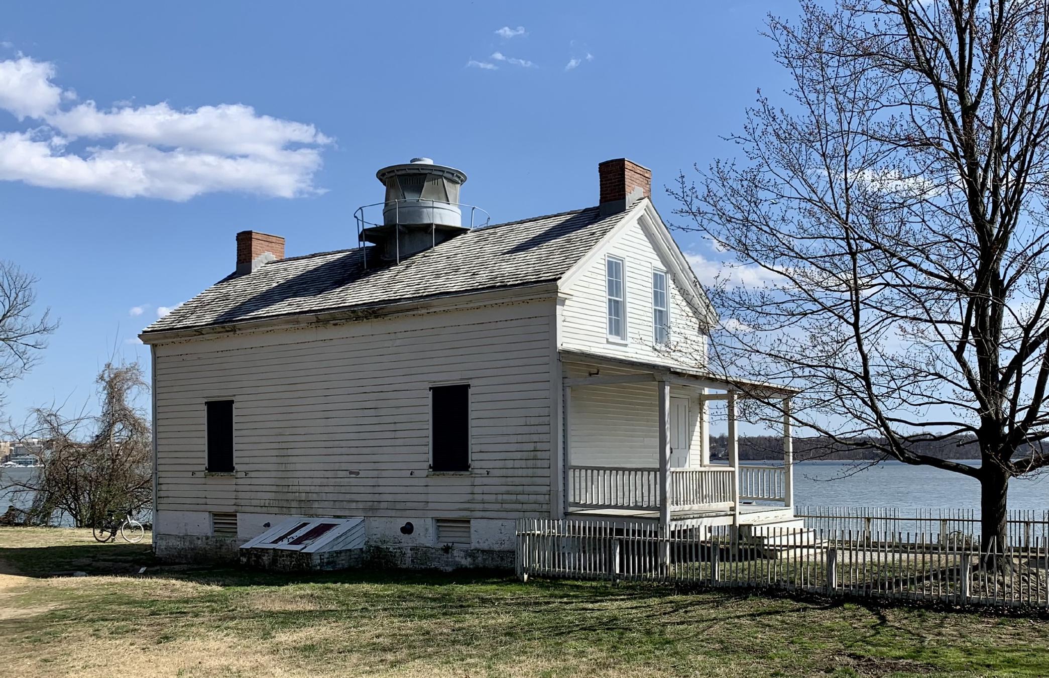
APK · via Wikimedia Commons · CC BY-SA 4.0 Jones Point Park
Frame lighthouse built 1855 at the south boundary stone of the original District of Columbia; one of the few surviving Potomac River inland lighthouses. …
Bruce Andersen from Washington, DC · via Wikimedia Commons · CC BY-SA 2.0 King Street
Fourth of the original DC southwestern boundary stones; the marker straddles the Alexandria-Arlington line. NRHP-listed 1991.
Hero image · pending Parker-Gray neighborhood
Historically African-American residential and commercial district north and west of Old Town, anchored by the Parker-Gray School. NRHP-listed 2010.
Hero image · pending Rosemont Historic District
Streetcar-suburb residential neighborhood developed 1908 onward on the western edge of Alexandria, characterized by Colonial Revival and Craftsman houses. …
Hero image · pending South Richmond Highway
Mid-rise commercial office building on South Richmond Highway (Alexandria's Route 1 corridor), owned/operated by the The Androus family. Established by 1971 …
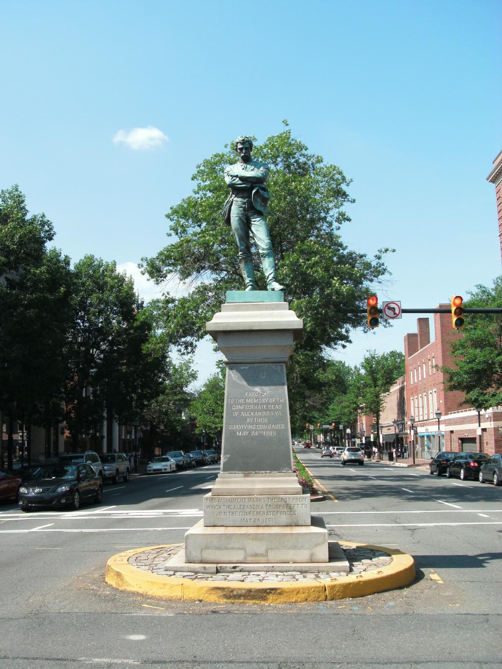
Ser Amantio di Nicolao Che dicono a Signa? Lo dicono a Signa. · via Wikimedia Commons · Public domain South Washington Street and Prince Street
Confederate monument cast 1889 by Caspar Buberl, relocated from the intersection of Washington and Prince streets on June 2, 2020. NRHP-listed 2017.
Bruce Andersen from Washington, DC · via Wikimedia Commons · CC BY-SA 2.0 Sw No 5 Boundary Marker
Fifth of the original DC southwestern boundary stones, near the Arlington line. NRHP-listed 1991.
Farragutful · via Wikimedia Commons · CC BY-SA 3.0 Town Of Potomac
Early-20th-century streetcar-suburb neighborhood incorporated as the independent Town of Potomac, annexed by Alexandria in 1930. NRHP-listed 1992.
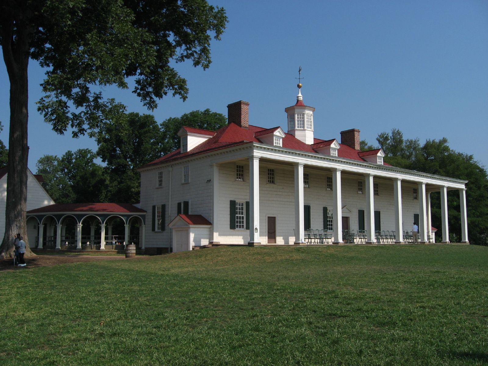
Ken Lund from Reno, Nevada, USA · via Wikimedia Commons · CC BY-SA 2.0 3200 Mount Vernon Memorial Highway
Five-farm plantation on the Potomac owned by George Washington from 1761 until his death in 1799; home to Washington, his family, and more than three hundred …
Hero image · pending Belvoir Plantation
The c. 1741 manor house of William Fairfax on the southern Northern Neck proprietary tract — social anchor of the colonial Fairfax–Washington circle, where …
The Ramsay House operating as the Old Ramsay Tavern, c. 1940 — an actual King Street neighborhood bar two years before the 1942 fire that destroyed most of the historic fabric. The 1956 reconstruction you see today is a Williamsburg-styled recreation of this earlier building. "Old Ramsay Tavern," Alexandria, c. 1940 — From Days Gone By, City of Alexandria (fair use) 221 King Street
Small frame house at the northeast corner of King and Fairfax Streets, traditionally held to be the oldest extant house in Alexandria — though the building you …
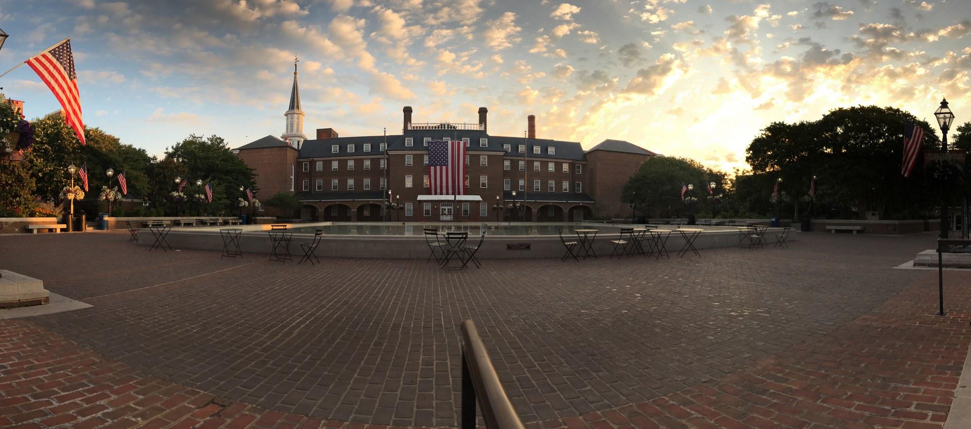
Market Square at sunrise, July 2017 — the city's eighteenth-century public square in its weekday-morning calm, framed by City Hall and the Fourth-of-July flags hung along the lamp posts. © KingSt.com, July 2017 301 King Street
Public square at 301 King Street fronting Alexandria City Hall — site of an open-air farmers market continuously operated since 1753, the longest-running …
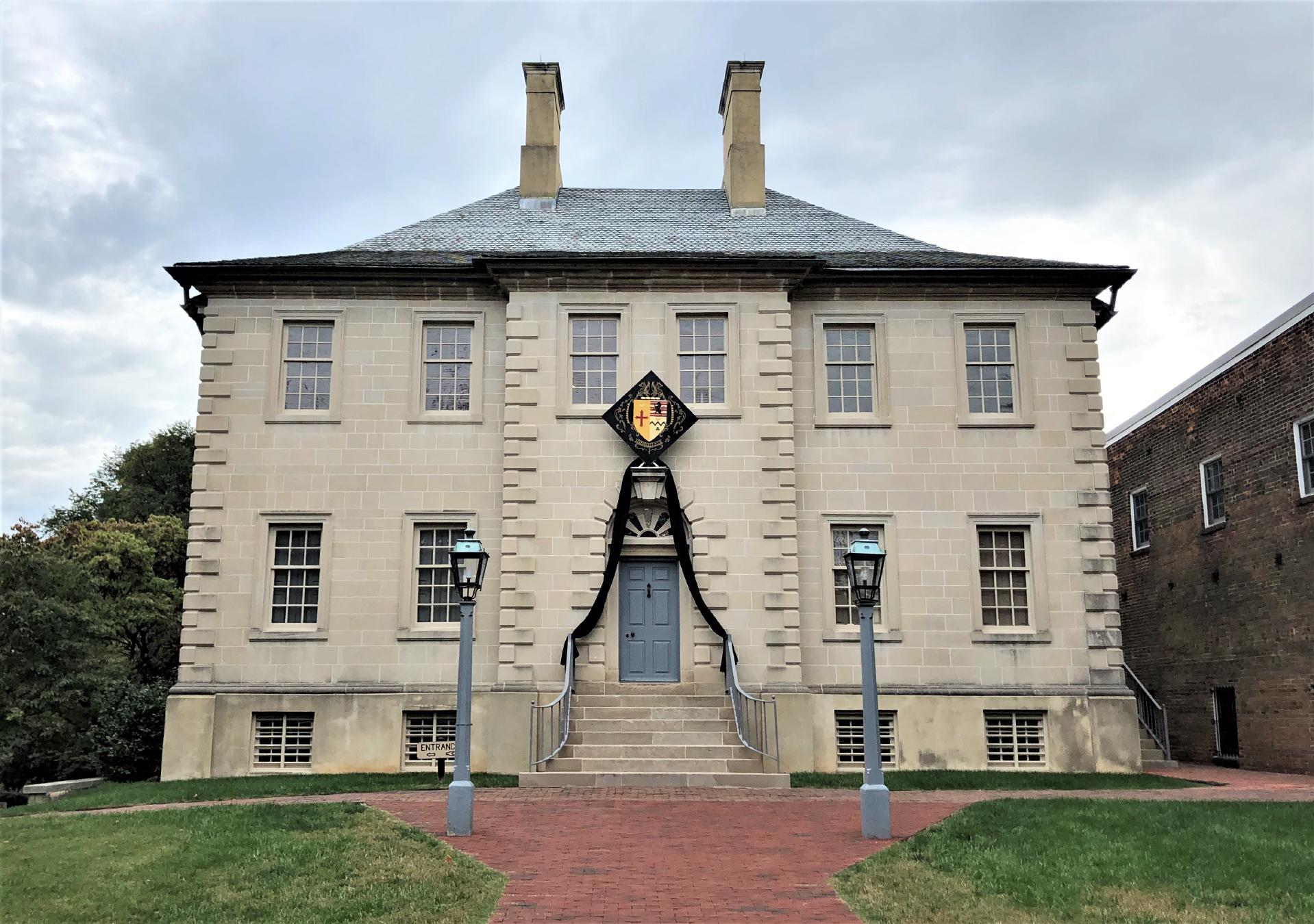
Beyond My Ken · via Wikimedia Commons · CC BY-SA 4.0 121 North Fairfax Street
Stone Georgian mansion built in 1753 by Scottish merchant John Carlyle; headquarters in April 1755 for General Edward Braddock's Congress of five royal …
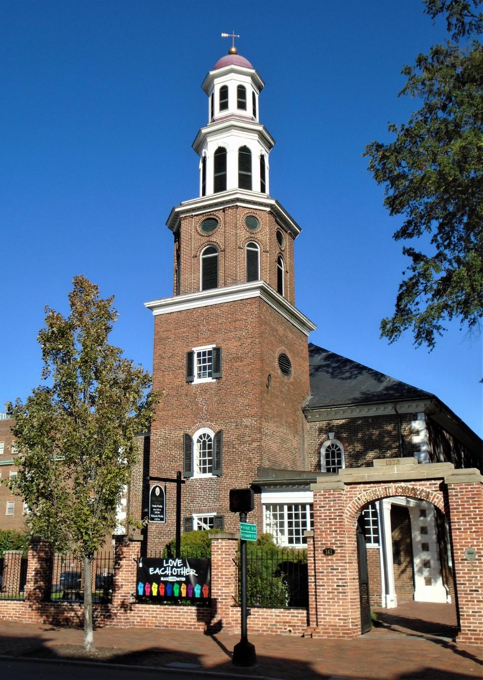
Beyond My Ken · via Wikimedia Commons · CC BY-SA 4.0 118 North Washington Street
Alexandria's Georgian-style Episcopal parish church, consecrated in 1773; pew owners included George Washington and, decades later, the Lee family.
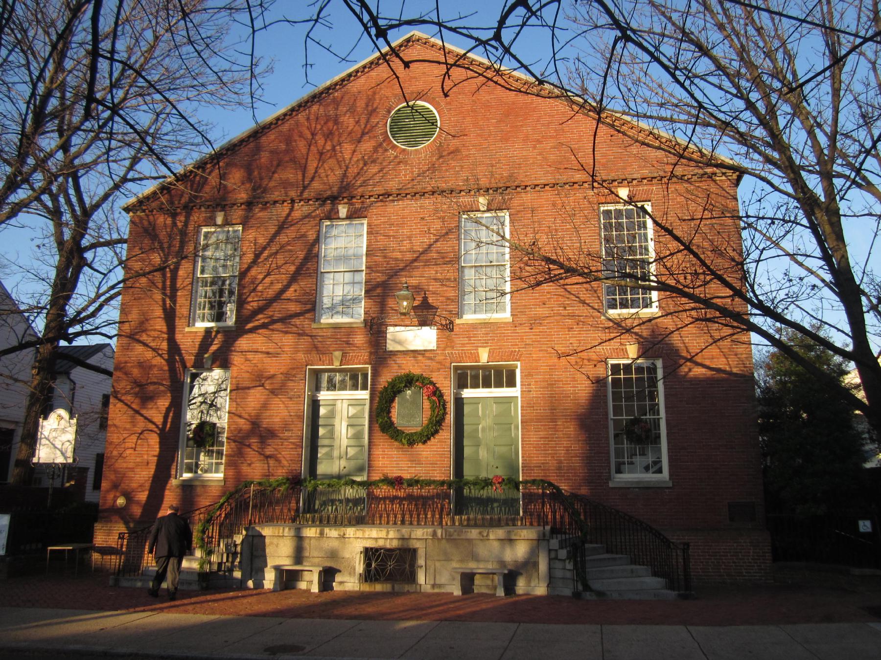
Doug Kerr from Albany, NY, United States · via Wikimedia Commons · CC BY-SA 2.0 321 South Fairfax Street
Brick Presbyterian meeting house begun in 1775; site of the city's memorial services for George Washington on December 29, 1799, four days before his …
Beyond My Ken · via Wikimedia Commons · CC BY-SA 4.0 134 North Royal Street
An 18th-century tavern complex at 134 North Royal Street that hosted George Washington's final Birthnight Ball in 1799 and served as a social and political …
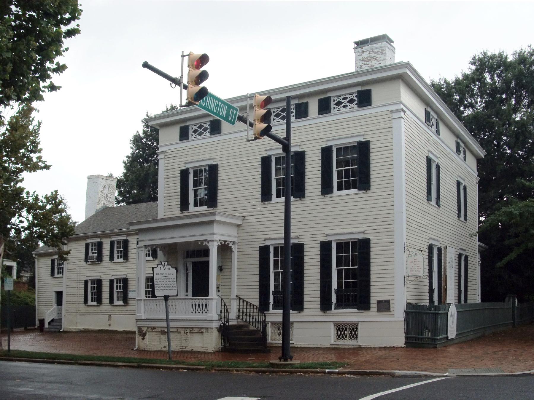
The original uploader was Ser Amantio di Nicolao at English Wikipedia . · via Wikimedia Commons · CC BY 3.0 614 Oronoco Street
Federal-style house built in 1785 by Philip Richard Fendall on land acquired from the Lee family. Occupied by a rotating cast of Lee family members through the …
Hero image · pending 614 Wolfe Street
Two-story brick schoolhouse built 1786 on Wolfe Street. George Washington was a founding trustee and bequeathed funds for free education of poor children. Later …
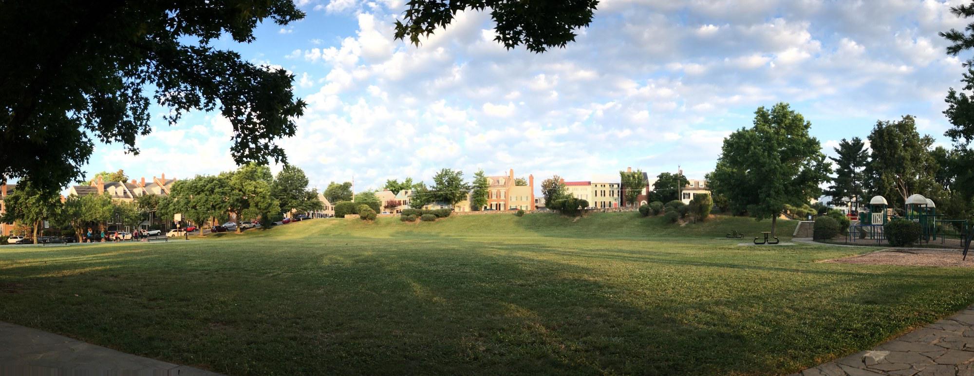
Windmill Hill Park at sunrise, July 2017 — the open grass meadow that once held Robert Townshend Hooe's c. 1791 grain windmill, with the Old Town row houses of South Union Street rising on the inland side and the playground visible at right. © KingSt.com, July 2017 501 South Union Street
Six-acre city park at 501 South Union Street, occupying the south Old Town waterfront hill that gave its name first to a c. 1791 wind-driven grain mill and then …
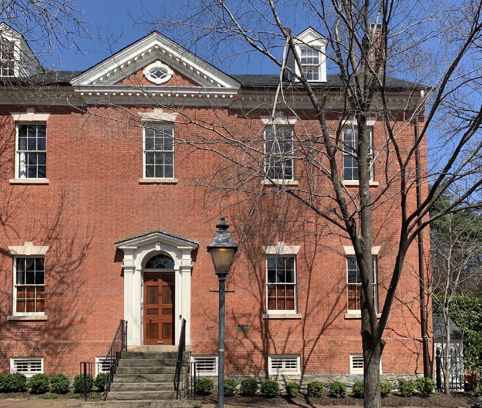
APK · via Wikimedia Commons · CC BY-SA 4.0 607 Oronoco Street
Federal-era house at 607 Oronoco Street rented by Anne Carter Lee from about 1812; principal childhood residence of her son Robert E. Lee before his 1825 …
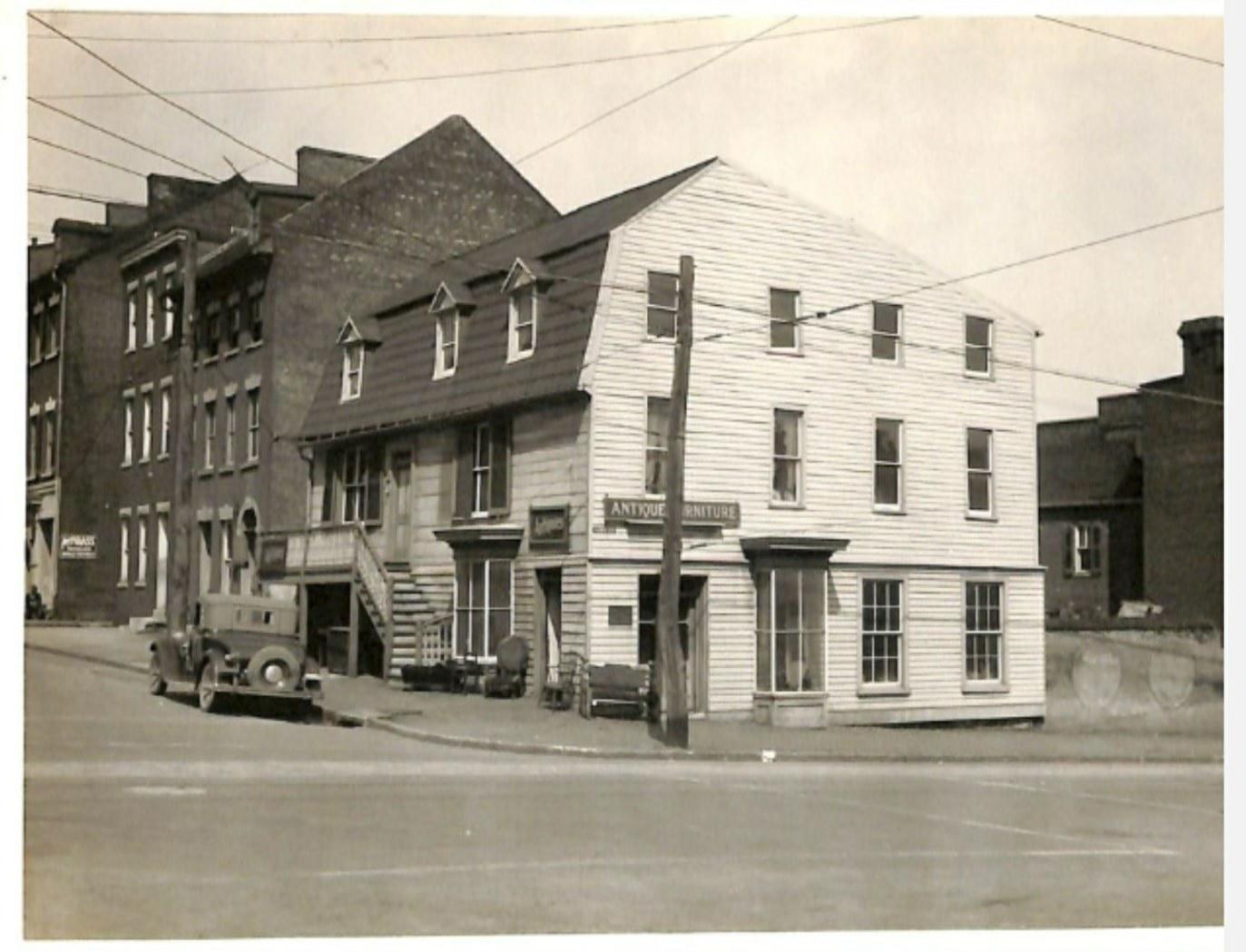
![Old Loyd [i.e. Lloyd] House, Alexandria, Va.](/images/gtdju7ejdnwoq7p/old_loyd_i_e_lloyd_house_alexandria_va_2rutnb54Yg._hu_dff9ce9c6762818.jpg)
Old Loyd [i.e. Lloyd] House, Alexandria, Va. · Library of Congress, Prints & Photographs Division · http://www.loc.gov/item/2016803285/ 220 North Washington Street
Late-Georgian 1797 townhouse at the corner of North Washington and Queen built by merchant John Wise. Charles Lee, U.S. Attorney General and brother of …
Hero image · pending 9000 Richmond Highway
Federal-style brick mansion built 1800–1805 by Lawrence Lewis and Nelly Custis Lewis on a 2,000-acre tract carved from the Mount Vernon estate as their wedding …
The 1807 Bank of Alexandria building at 133 N. Fairfax Street, Old Town Alexandria — the surviving Federal-style banking house after the late-1960s demolition of the Civil War-era hotel expansion. Photographed June 2014. Bank of Alexandria photographed by Ken Lund / Flickr, CC BY-SA 2.0 (2014) 133 North Fairfax Street
Federal-style 1807 banking house at the corner of North Fairfax and Cameron Streets — the surviving home of the Bank of Alexandria, chartered in 1792 as the …
Hero image · pending 1100 Wilkes Street
Cluster of twelve adjacent burial grounds stretching across the 1100 block of Wilkes Street, including Methodist Protestant, Presbyterian, Quaker, Black …
Theodore Christopher · via Wikimedia Commons · CC0 1315 Duke Street
Federal-style brick house at 1315 Duke Street built in the 1810s by Brigadier General Robert Young of the DC Militia; from 1828 to 1837 the headquarters of …
Hero image · pending 2525 King Street
Single-family residence on the upper / western stretch of King Street, in the corridor that became Alexandria's Middle Turnpike (chartered 1813, completed …
Hero image · pending 609 Oronoco Street
Federal-style brick house at 609 Oronoco Street where Quaker educator Benjamin Hallowell ran a boys' classical school from 1824. Robert E. Lee received his …
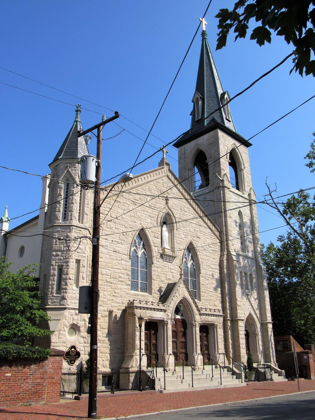
Farragutful · via Wikimedia Commons · CC BY-SA 4.0 310 South Royal Street
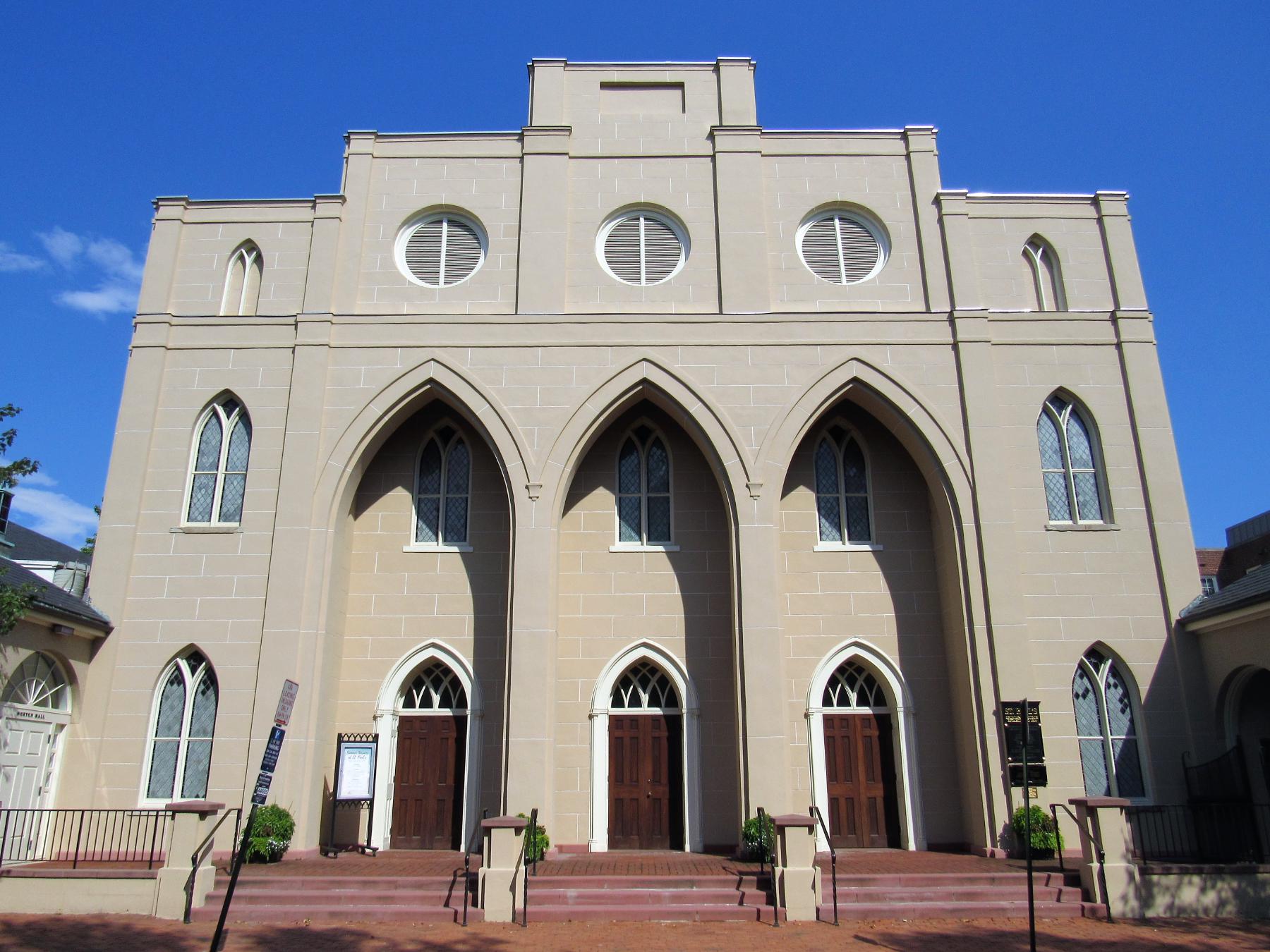
Founded in 1795 as the first Catholic parish in Virginia. Present Greek Revival church on South Royal Street completed 1827; congregation has worshipped …
John W. Cross · via Wikimedia Commons · CC BY 2.5 3737 Seminary Road
Episcopal theological seminary founded in Alexandria in 1823 and relocated to its present hilltop campus in 1827. Occupied by Union forces during the Civil War …
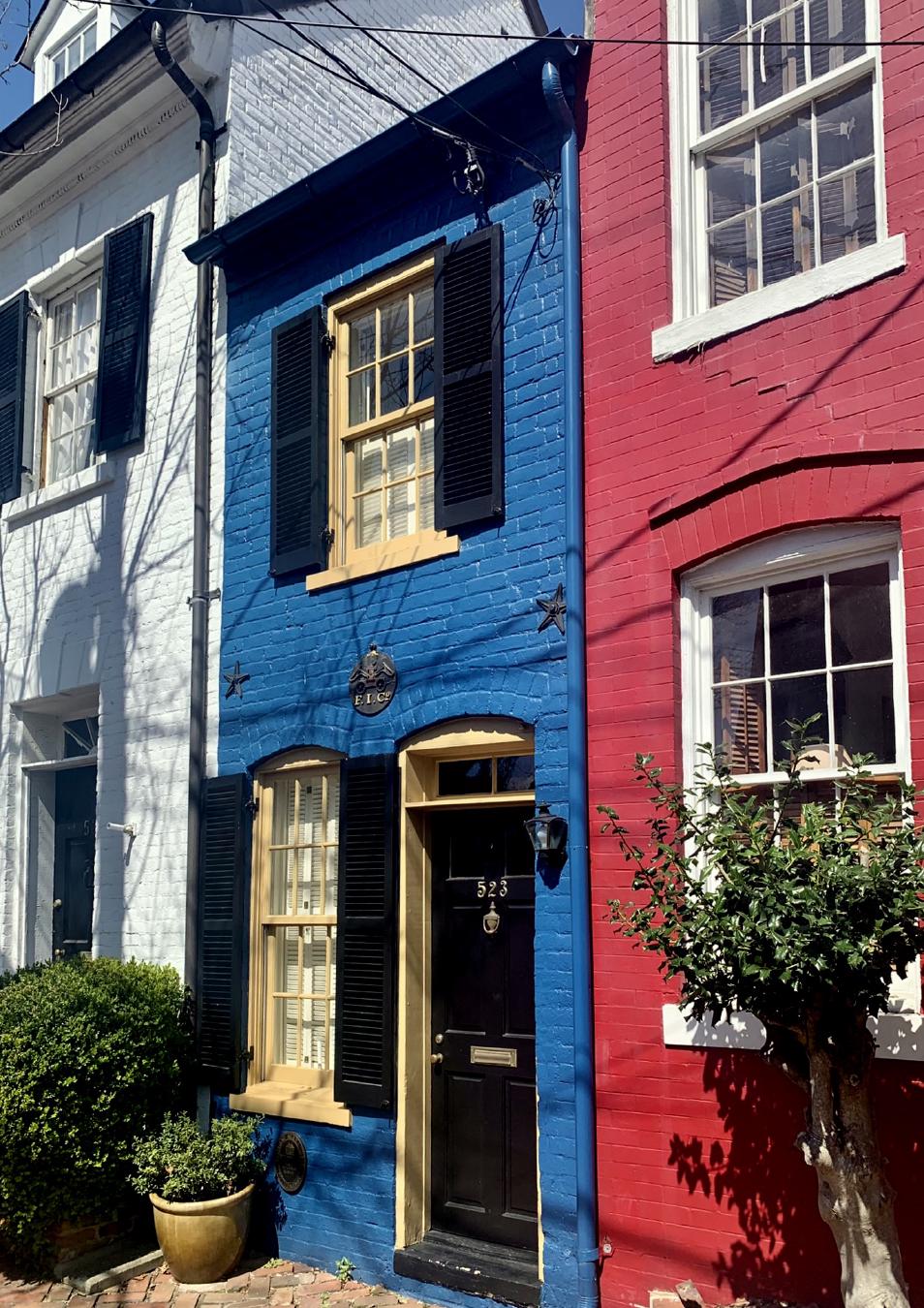
APK · via Wikimedia Commons · CC BY-SA 4.0 523 Queen Street
Two-story brick "spite house" 7 feet 6 inches wide, infilling the alley between 521 and 525 Queen Street. Built in 1830 by John Hollensbury to block …
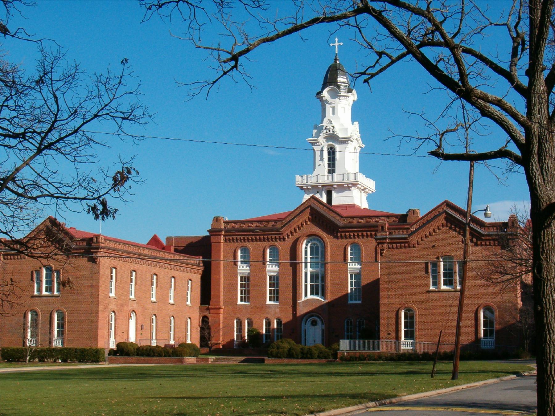
Episcopal High School's 100-acre campus from above, September 2019 — Hoxton House (white columns, right) anchors the south end; the Collegiate Gothic academic buildings ring the central quad. Aerial view of Episcopal High School, by Penguino2020 / Wikimedia Commons, CC BY-SA 4.0 (2019) 1200 North Quaker Lane
The first high school in Virginia, founded 1839 by Bishop William Meade of the Episcopal Diocese on a 100-acre campus west of Old Town. First principal William …
Placeholder illustration of Lyceum. Seed placeholder — KingSt.com, 2026. To be replaced with archival photograph. 201 South Washington Street
Greek Revival building completed in 1839 as the Alexandria Lyceum, a subscription library and lecture hall. Served as a Union hospital during the Civil War and, …
SDC at en.wikipedia · via Wikimedia Commons · Public domain 1 Wilkes Street
The 1843 stone tide lock at the southern terminus of the Alexandria Canal, which connected the Chesapeake & Ohio Canal at Georgetown with the Alexandria …
Hero image · pending 201 Prince Street
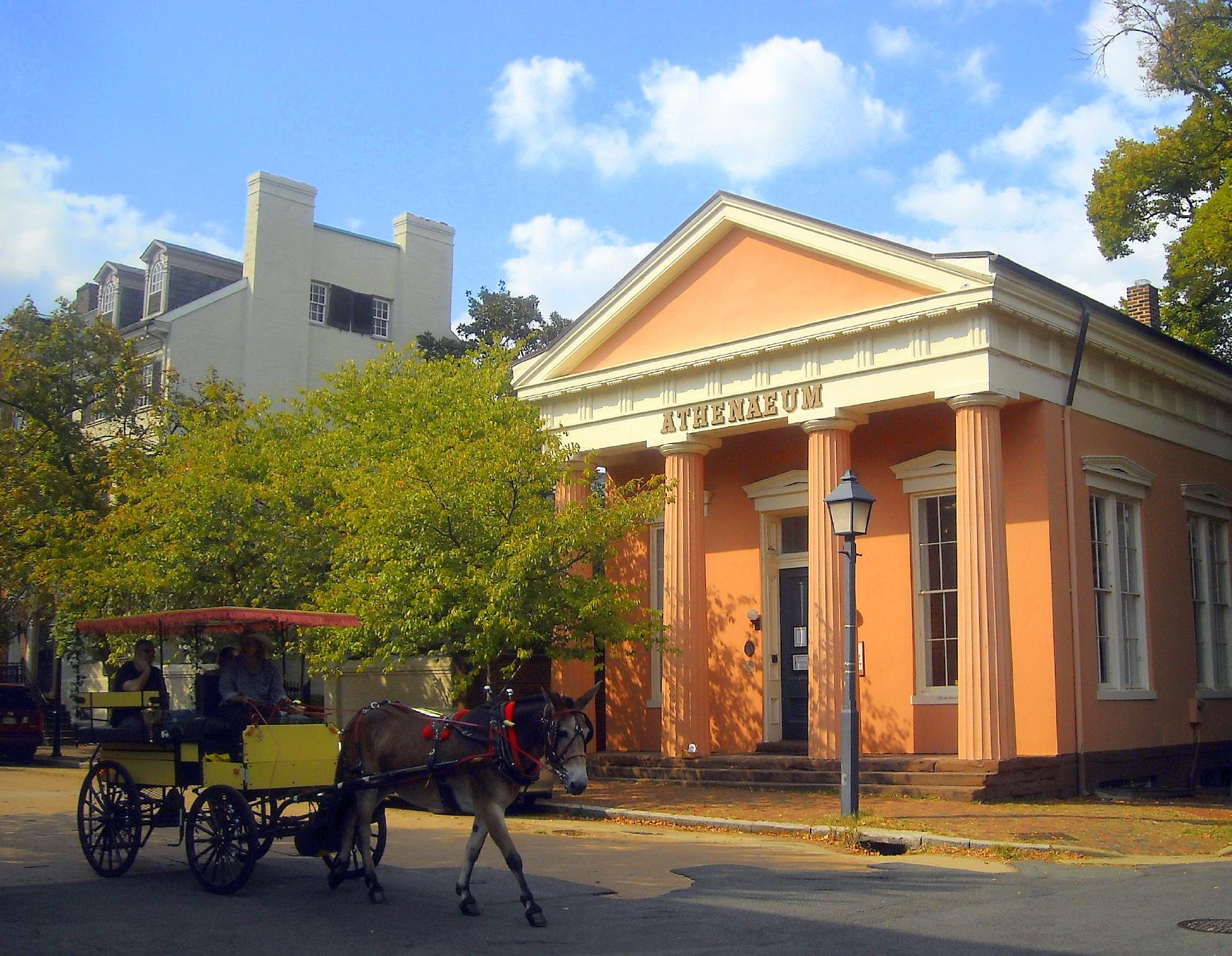
Greek Revival temple-front building completed 1851 at 201 Prince Street as the Bank of the Old Dominion. Used during the Civil War as a Union commissary, later …
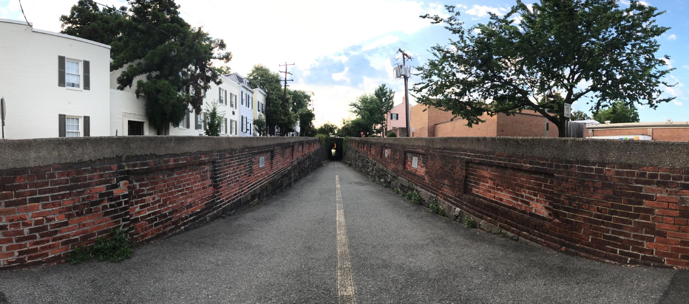
Wilkes Street Tunnel from the western approach, July 2017 — the brick-arched railroad tunnel cut beneath Wilkes Street in the early 1850s for the Orange & Alexandria Railroad to reach the Potomac wharves, today an Old Town pedestrian and bicycle passage. © KingSt.com, July 2017 Wilkes Street (between South Royal and South Lee)
Brick-arched railroad tunnel carved beneath Wilkes Street in the early 1850s for the Orange & Alexandria Railroad to reach the city's wharves on the …
Hero image · pending 107 South Alfred Street
1855 Italianate firehouse at 107 South Alfred Street, home of the Friendship Fire Company — founded 1774, the oldest volunteer fire company in Alexandria. …
Ser Amantio di Nicolao · via Wikimedia Commons · CC BY-SA 3.0 2823 King Street
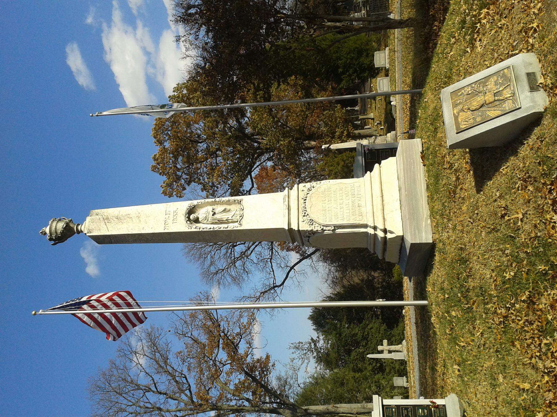
Twenty-two-acre garden cemetery in Alexandria's Rosemont district, chartered 1856 by thirty Alexandrians on land sold from the estate of Hugh C. Smith. A …
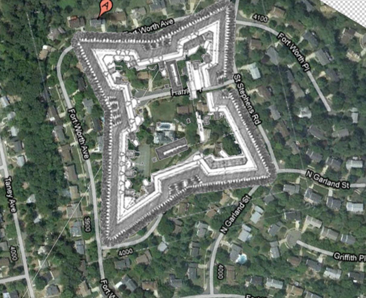
The 1864 Fort Worth engineering plan superimposed on modern Seminary Ridge satellite imagery — the fort's star-shaped earthwork still imprinted on today's residential street grid. Composite by KingSt.com (1864 NARA plan over modern aerial), 2026 Seminary Hill (off Seminary Road, near St. Stephens Road)
Layered Seminary Hill site that was the country estate "Muckross" of Burke & Herbert Bank co-founder Arthur Herbert, the Civil War earthwork Fort …
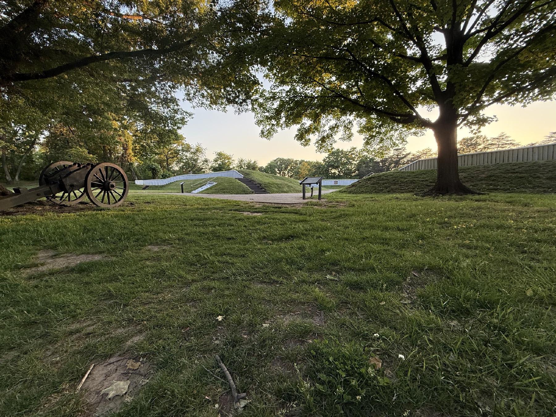
Restored Fort Ward earthwork, Seminary Hill, Alexandria — May 9, 2026. © KingSt.com, May 2026 site visit 4301 West Braddock Road
Earthwork fort raised in 1861 as part of the ring of Union fortifications around Washington; the fifth-largest of the Civil War defenses of the capital. After …
Placeholder illustration of Alexandria National Cemetery. Seed placeholder — KingSt.com, 2026. To be replaced with archival photograph. 1450 Wilkes Street
One of the original fourteen national cemeteries established in 1862, interring Union dead from the Civil War, including United States Colored Troops reinterred …
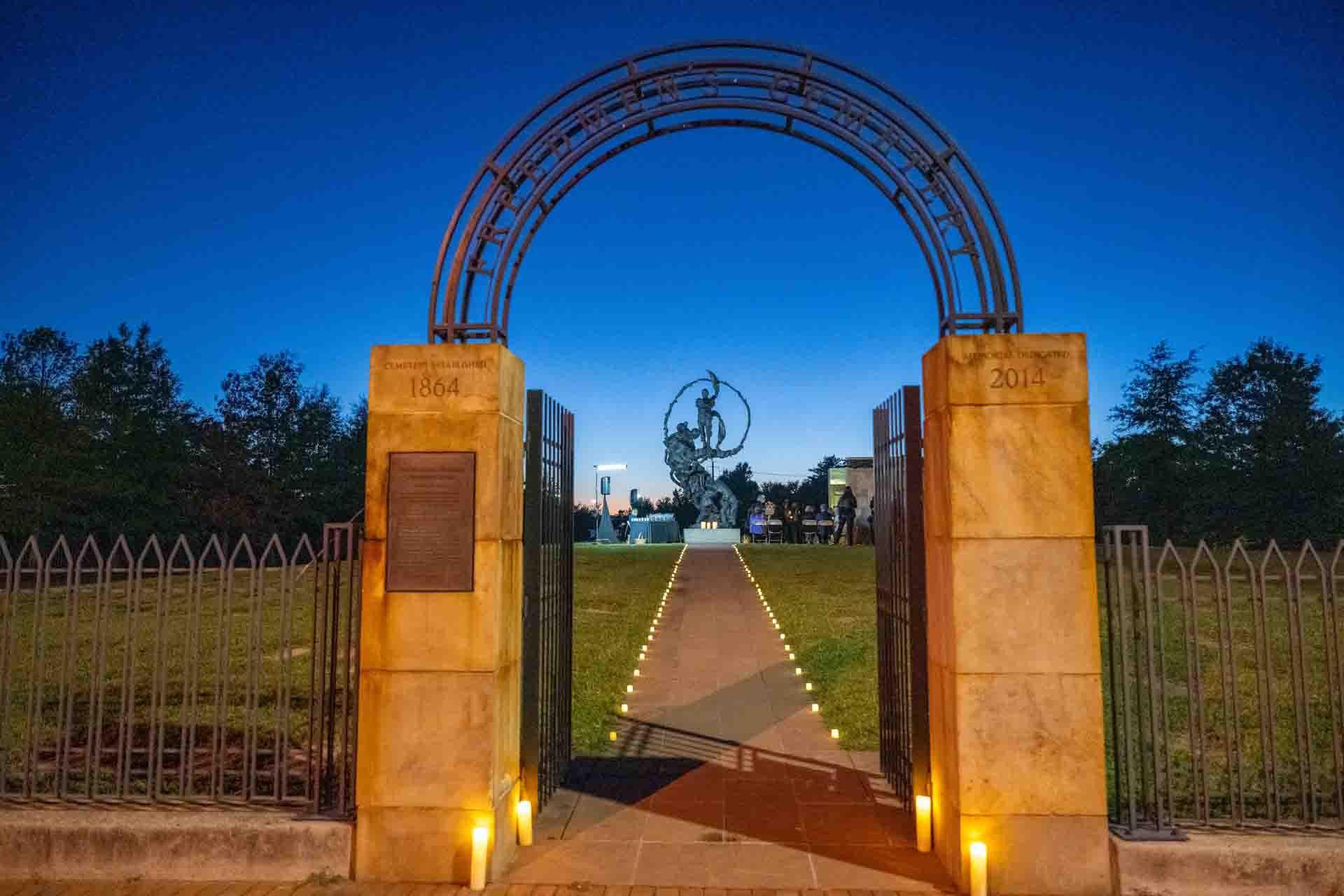
Tenth-anniversary candlelight vigil at the gate of the Contrabands and Freedmen Cemetery Memorial, 2024 — looking past the inscribed pillars and the lit walkway to Mario Chiodo's bronze sculpture, "The Path of Thorns and Roses," at the heart of the memorial. 10th-anniversary candlelight vigil, 2024 — City of Alexandria (fair use) 1001 South Washington Street
Burial ground established in 1864 by the Union military government on the southern edge of Federally-occupied Alexandria for self-emancipated Black people — …
Placeholder illustration of Louverture Hospital Site. Seed placeholder — KingSt.com, 2026. To be replaced with archival photograph. 219 South Payne Street
Union Army hospital established in February 1864 for U.S. Colored Troops and Black civilian refugees in occupied Alexandria. Named for Toussaint Louverture, the …
Market Square and Alexandria City Hall at sunrise, July 2017 — the brick plaza dressed for the Fourth of July with the American flag hung from the central facade. © KingSt.com, July 2017 301 King Street
Alexandria's seat of municipal government, market house, and — for most of the nineteenth century — the lodge hall and museum of Alexandria-Washington Lodge …
Hero image · pending 1200 Duke Street
Headquarters of T. J. Fannon & Sons at 1200 Duke Street, the Alexandria heating-fuel firm founded by Thomas J. Fannon as a wood-and-coal yard in 1885 and …
Placeholder illustration of Interarms Hq 10 Prince Street. Seed placeholder — KingSt.com, 2026. To be replaced with archival photograph. 10 Prince Street
Former office of International Armament Corporation (Interarms) at the foot of Prince Street; administrative headquarters of Samuel Cummings's arms-dealing …
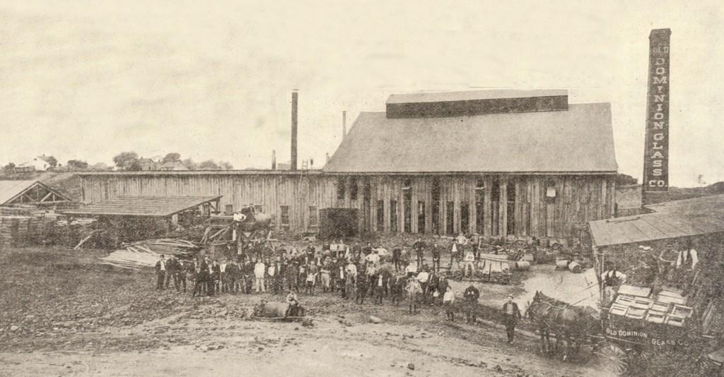
photographer not credited · via Wikimedia Commons · Public domain 300 North West Street
Glass bottle and jar works that operated in west-end Alexandria from the 1890s until the Depression, employing hundreds of workers including children before …
Placeholder illustration of Interarms Warehouse Complex South Union. Seed placeholder — KingSt.com, 2026. To be replaced with archival photograph. South Union Street
Complex of converted warehouse buildings along South Union Street used by Interarms from the late 1950s to the late 1990s to store surplus military small arms. …
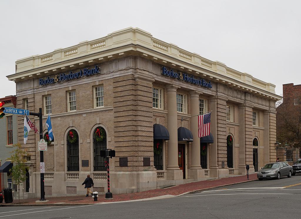
The Burke & Herbert Bank building in Alexandria, Virginia, a city immediately south of Washington, D.C., and once a larger, more thriving river port than the nation's capital city · Library of Congress, Prints & Photographs Division · http://www.loc.gov/item/2020724810/ 100 South Fairfax Street
The 1903 neoclassical home of Burke & Herbert Bank at the corner of King and South Fairfax streets, the bank's sixth and final headquarters after a …
Hero image · pending Richmond Highway
~8,656-acre U.S. Army installation along Richmond Highway in Fairfax County, established 1917 as Camp A.A. Humphreys, renamed Fort Humphreys 1922, renamed Fort …
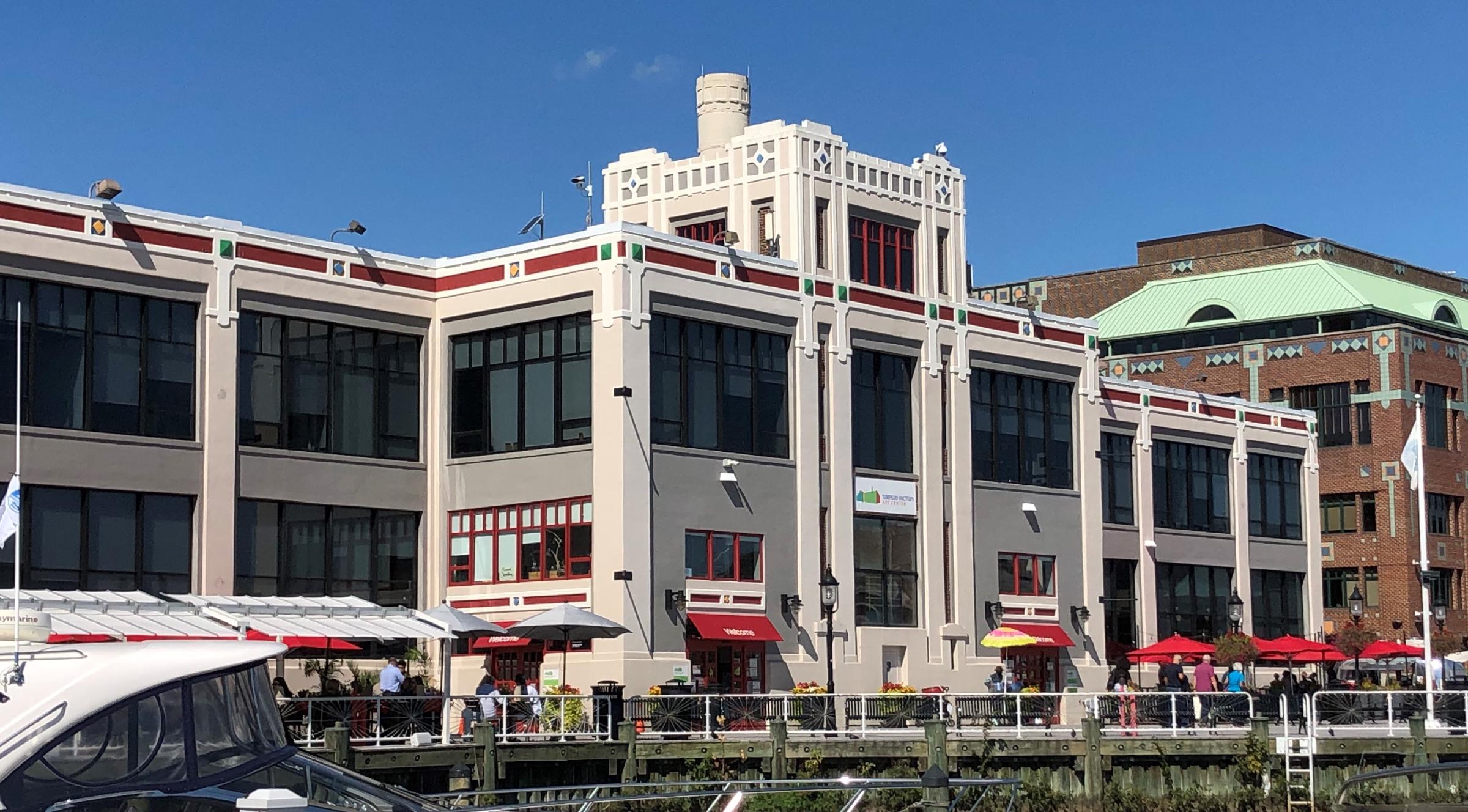
Beyond My Ken · via Wikimedia Commons · CC BY-SA 4.0 105 North Union Street
Waterfront munitions plant built in 1918 as the U.S. Naval Torpedo Station; produced torpedoes through World War II, served as federal records storage after the …
Hero image · pending 6023 Fort Hunt Road
1924 private country club at 6023 Fort Hunt Road on the Potomac River south of Old Town Alexandria. 18-hole golf course, tennis courts, and clubhouse facilities …
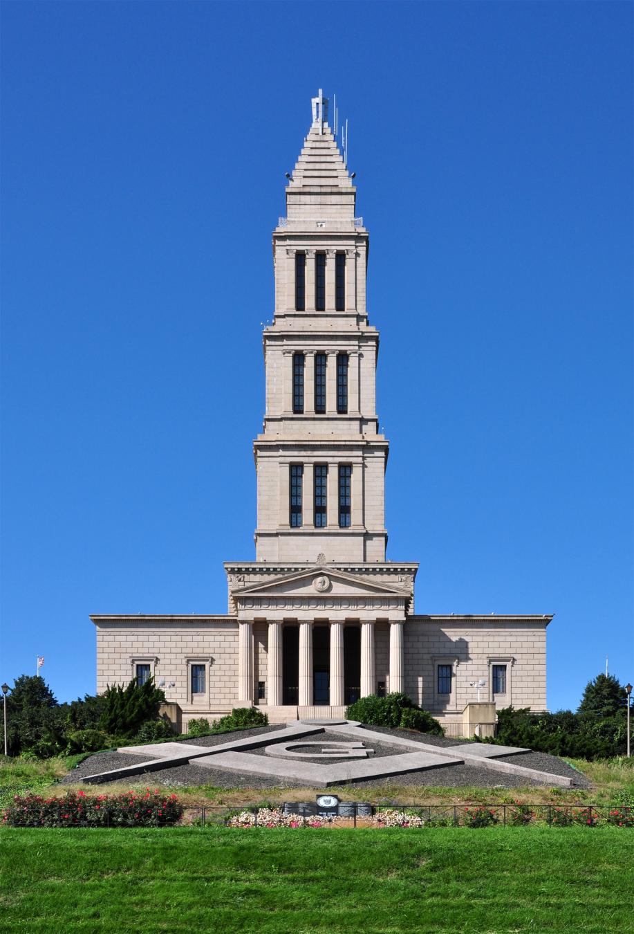
Joe Ravi ( Shutterstock iStock Dreamstime ) · via Wikimedia Commons · CC BY-SA 3.0 101 Callahan Drive
A 333-foot granite tower atop Shuter's Hill, completed 1932 by Freemasons across the United States to honor George Washington as Charter Master of …
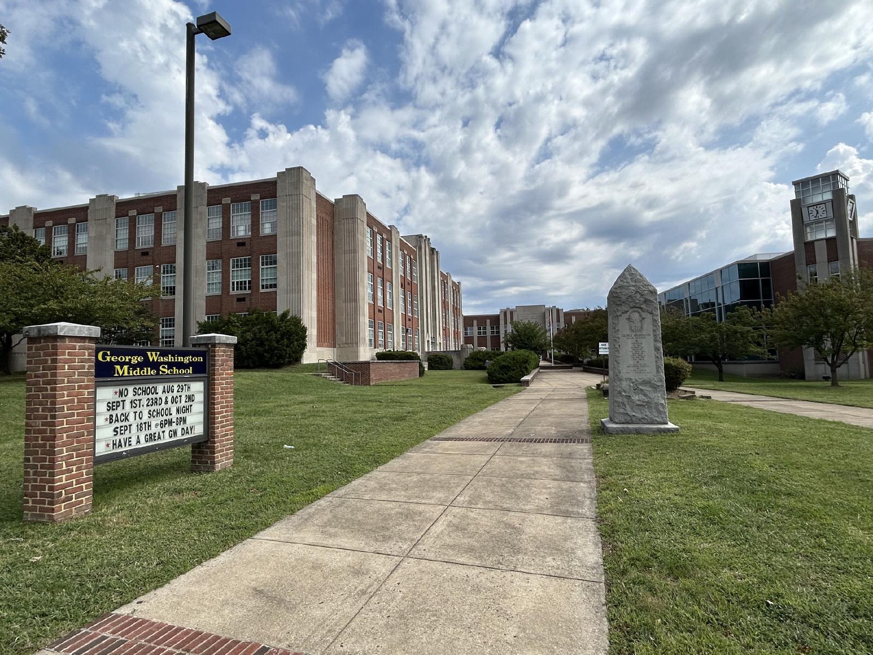
George Washington Middle School on Mount Vernon Avenue in Del Ray, looking northeast along the front walk — the 1934 Stripped Classical school building at left, the modern clock-tower addition at right, and (at right of the walk) the granite WWII memorial obelisk erected by the graduating classes of 1943-1947 to the fifty GW alumni who did not come back from the war. © KingSt.com, 2024 1005 Mount Vernon Avenue
Brick Stripped Classical / Art Deco school on Mount Vernon Avenue in Del Ray, built 1934 and opened 1935 as George Washington High School — a consolidation of …
Placeholder illustration of Alexandria Library 1939. Seed placeholder — KingSt.com, 2026. To be replaced with archival photograph. 717 Queen Street
Alexandria's first free public library, opened on Queen Street in 1937, and site of a sit-in on August 21, 1939 that is among the earliest documented …
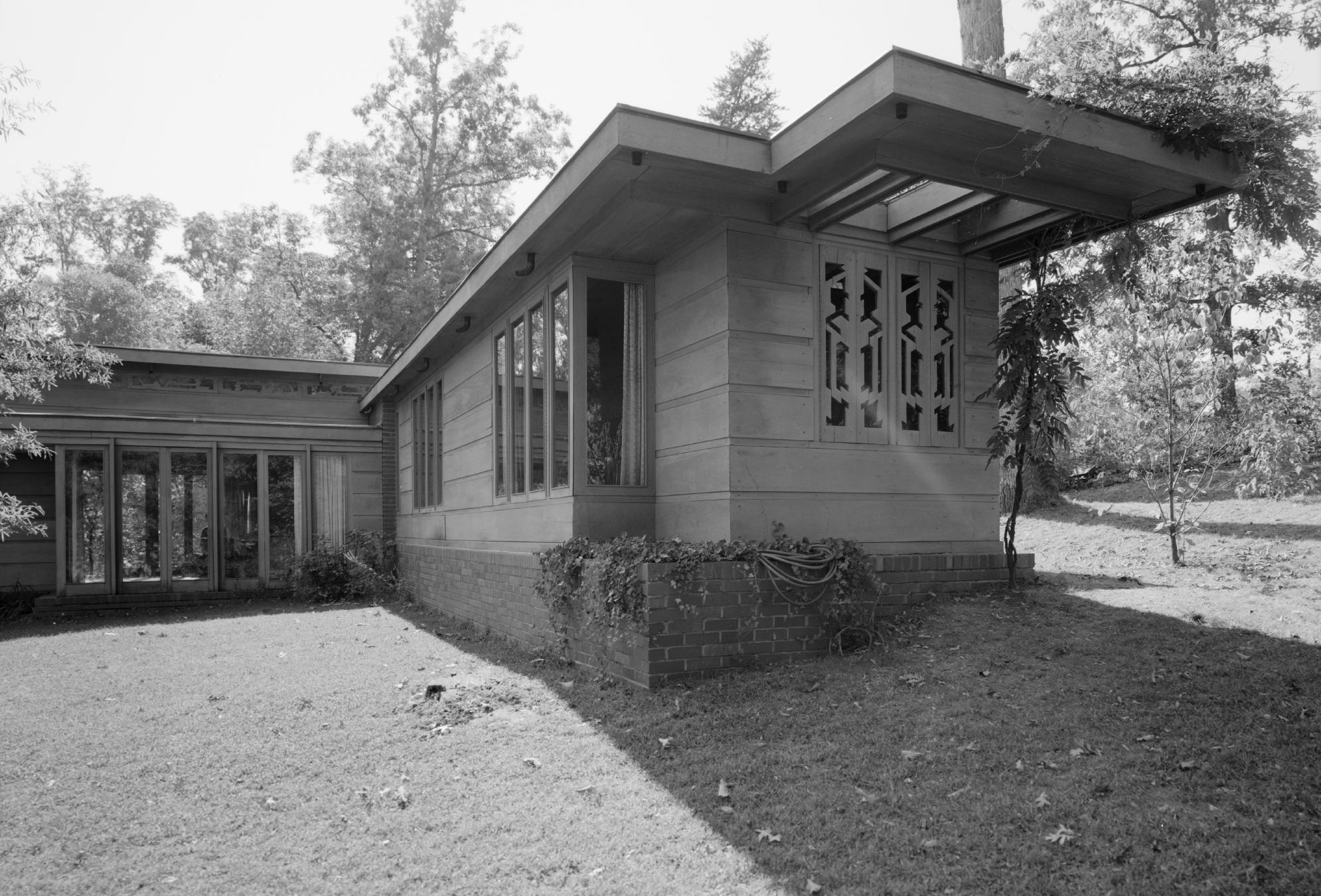
Unknown author Unknown author · via Wikimedia Commons · Public domain 9000 Richmond Highway
Frank Lloyd Wright Usonian house built in 1940 for journalist Loren Pope; relocated to the 9000 Richmond Highway parcel in 1964 to escape Interstate 66 …
Hero image · pending 4800 Duke Street
164-acre former U.S. Army installation on Duke Street, active 1942–1995. Headquartered the Defense Logistics Agency, the Defense Mapping Agency, and elements of …
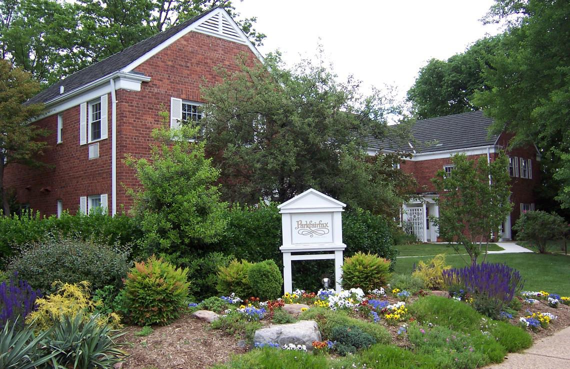
Unknown · via Wikimedia Commons · CC BY 2.5 Parkfairfax Historic District
132-acre Colonial Revival garden-apartment community completed 1941–1943 by the Metropolitan Life Insurance Company under FHA defense-housing financing — an …
User:AlbertHerring · via Wikimedia Commons · CC BY 3.0 1500 Belle View Boulevard
Mid-century shopping center on the former River Farm tract, one of the five constituent farms of George Washington's Mount Vernon plantation. Juxtaposes a …
Placeholder illustration of Parker Gray School Site. Seed placeholder — KingSt.com, 2026. To be replaced with archival photograph. 900 Wythe Street
Site of Alexandria's segregated public school for Black students, opened in 1920 at 900 Wythe Street and replaced in 1950 by a new Parker-Gray High School …
Hero image · pending 1000 Saint Stephens Road
Upper School (grades 9–12) of St. Stephen's & St. Agnes School, occupying the Saint Stephens Road campus opened in January 1957 by St. Stephen's …
Hero image · pending 201 Cambridge Road
Catholic co-educational secondary school founded in 1964 by the Diocese of Arlington on Cambridge Road; alumni include Dave Grohl (transferred junior, early …
Hero image · pending 530 South St. Asaph Street
Continuously operating school site on South St. Asaph Street whose institutional lineage runs from the city's segregated Black schools of the late …
Hero image · pending 2461 Eisenhower Avenue
Mid-rise office building completed 1968 at 2461 Eisenhower Avenue — the first major structure on the seventy-acre Eisenhower Valley parcel that Hubert N. …
Ben Schumin · via Wikimedia Commons · CC BY-SA 3.0 Strand Street
The Potomac waterfront from the Torpedo Factory south to Jones Point, subject to a decades-long redevelopment project that has converted former industrial and …
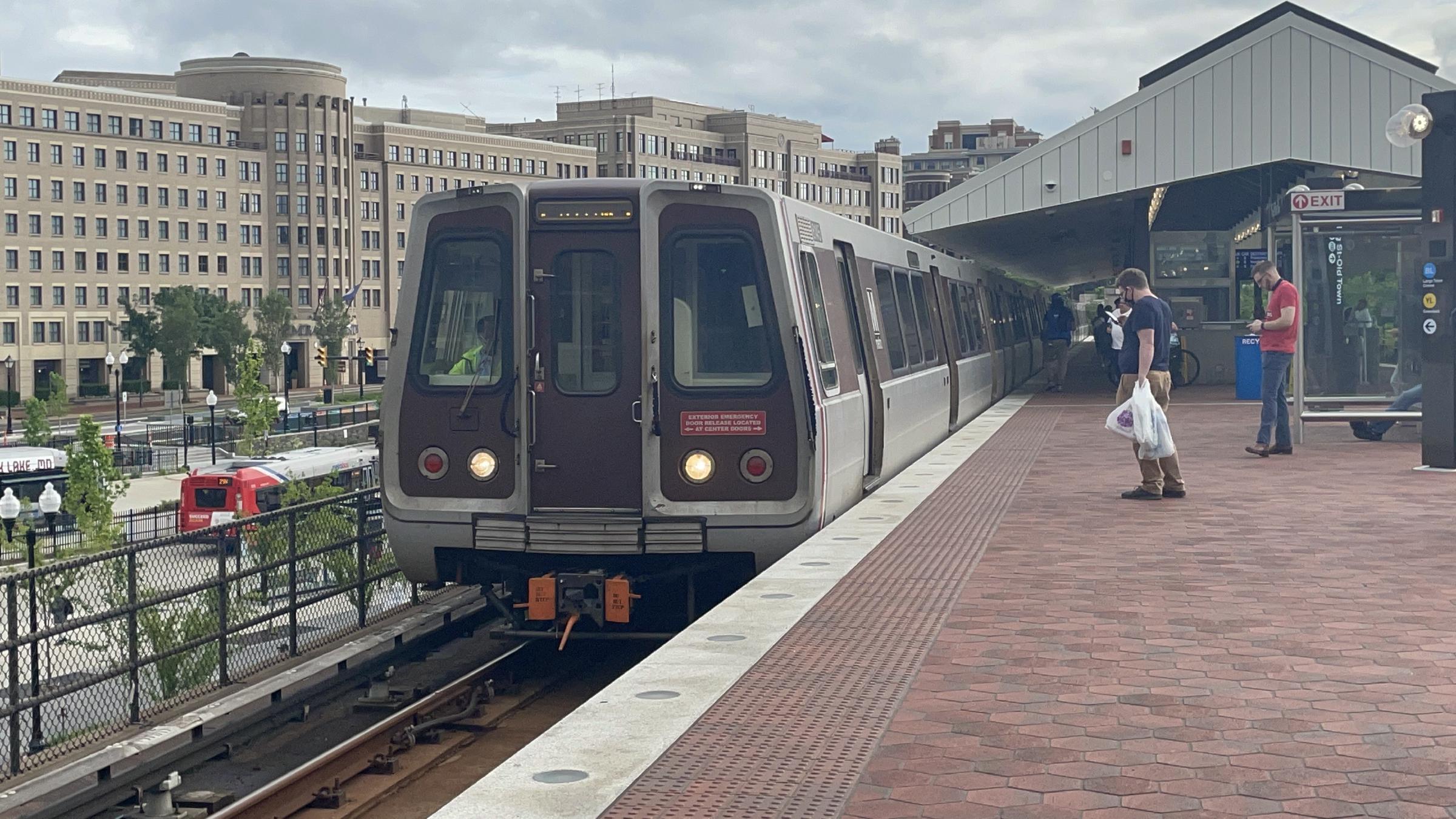
Er1ckRailfan · via Wikimedia Commons · CC BY-SA 4.0 1900 King Street
Washington Metro station opened December 1983 at the west end of King Street, catalyzing mixed-use redevelopment of the surrounding blocks over the subsequent …
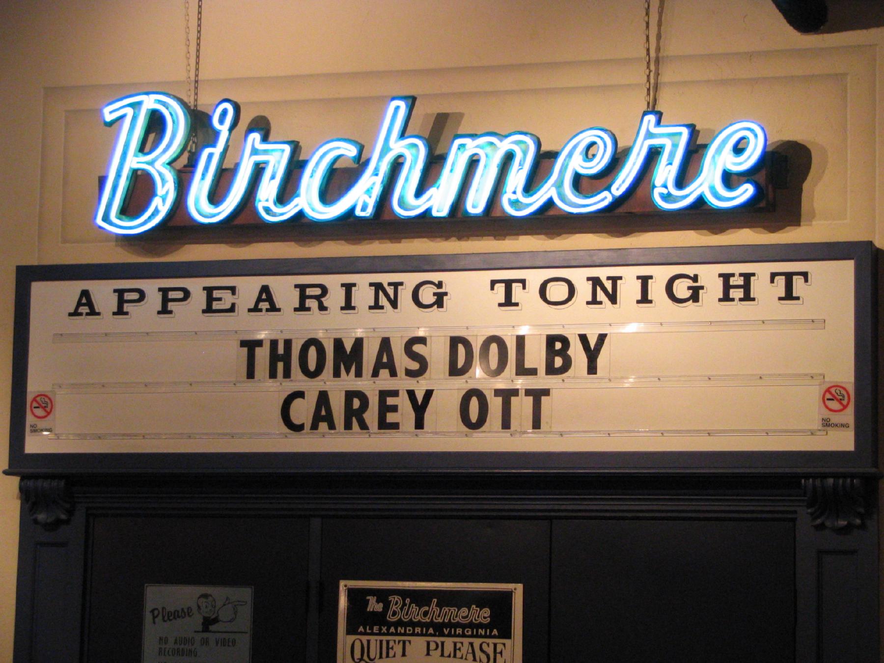
Rudi Riet from Washington, DC, United States · via Wikimedia Commons · CC BY-SA 2.0 3701 Mount Vernon Avenue
Listening-room music venue on Mount Vernon Avenue, founded in 1966 at an earlier location and relocated in 1997 to the present purpose-built hall. A nationally …
Hero image · pending Cameron Station Boulevard
45-acre civic park laid out across the former parade-ground center of 4800 Duke Street during the 1998–2002 LCOR redevelopment of the parcel. Named for Ben …
Hero image · pending 401 East Braddock Road
LEED Gold mixed-use commercial development at the corner of East Braddock Road, completed 2013–2015 by Jason Yates and his wife Loren on the long-blighted …