
501
South Union Street
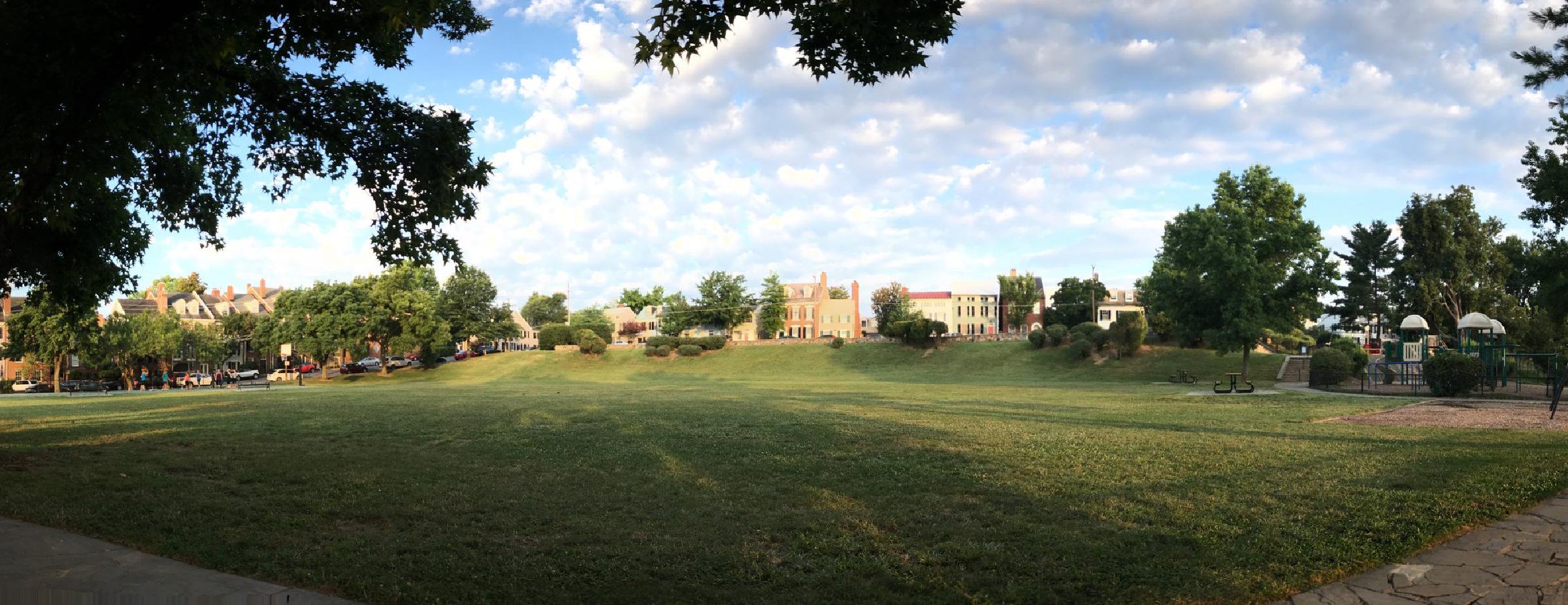
Six-acre city park at 501 South Union Street, occupying the south Old Town waterfront hill that gave its name first to a c. 1791 wind-driven grain mill and then to “Hayti” — the antebellum and Civil War-era free Black neighborhood that grew around the south end of the city. Two Alexandria Heritage Trail markers stand at the park entrance: the Windmill Hill marker (city marker series) and the African American Neighborhoods in the Civil War marker (African American Heritage Trail series).
- 1791approx
- Public park
- Extant
- Alexandria Heritage Trail (City marker series)
Place narrative
The rising ground at the south end of Old Town between South Union Street and the Potomac shoreline takes its name from the wind-driven grain mill that stood here in the late eighteenth century. Records associate the mill with the Alexandria merchant Robert Townshend Hooe and date its construction to about 1791; the mill served the wharves and warehouses of the south harbor district and was a prominent landmark visible from the river. The structure was gone by the early nineteenth century, but the name remained attached to the hill.
“Hayti” and the African American Civil War-era neighborhood
Through the antebellum decades and into the Civil War, the south end of the city — including the hill and the streets that fed it on Wolfe, Wilkes, and Gibbon — became one of the principal areas of free Black settlement in Alexandria, known locally as “Hayti” for the example set by the Haitian republic. Federal occupation of Alexandria from May 24, 1861 forward brought thousands of self-emancipated and recently freed people into and around the existing Hayti community; the African American Heritage Trail marker that stands at this corner today interprets that wartime concentration and its postwar afterlife 1001 South Washington Street 1001 South Washington Street Burial ground established in 1864 by the Union military government on the southern edge of Federally-occupied Alexandria for self-emancipated Black people — "contrabands" in … a few blocks south at 1001 South Washington was part of the same African American Civil War-era infrastructure of the city’s south end.
The park
The hill was opened as a public park in the twentieth century. The park today is an open landscape: a broad grass meadow sloping gently toward the Potomac; a playground, picnic facilities, and basketball and volleyball courts along the east side; an unfenced dog area; a walking trail through the wooded perimeter; and a waterfront edge that connects to the 1 Wilkes Street 1 Wilkes Street The 1843 stone tide lock at the southern terminus of the Alexandria Canal, which connected the Chesapeake & Ohio Canal at Georgetown with the Alexandria waterfront via a seven-mile … immediately to the north. The park is open dawn to dusk (sunrise to sunset) per the City of Alexandria’s parks office [1] City of Alexandria, "Windmill Hill Park" parks page Government record .
Two Alexandria Heritage Trail markers stand at the west-side entrance on South Union Street — the Windmill Hill marker (city Heritage Trail series) and the African American Neighborhoods in the Civil War marker (African American Heritage Trail series).
The 2003 plan and the shoreline restoration
In 2003 the Alexandria City Council adopted a long-range Windmill Hill Park plan that, among other improvements, called for replacing the existing bulkhead along the Potomac with a natural shoreline. The bulkhead replacement — a “living shoreline” of graded slopes, stone sills, and tidal marsh plantings rather than the hardened vertical seawall it superseded — has been carried out in phases since, restoring a stretch of riverfront edge to a more ecologically functional condition [1] City of Alexandria, "Windmill Hill Park" parks page Government record .
Timeline
3 chronological entries across 3 eras.
Windmill built on the south Old Town hill
Federal occupation reshapes the south-end African American neighborhood
Alexandria City Council adopts the Windmill Hill Park plan [1] Source City of Alexandria, "Windmill Hill Park" parks page
The building
- Public park
No images yet — contribute a photo.
Nearby in time
400 Fontaine Street 400 Fontaine Street
Lower School (JK through grade 5) of St. Stephen's & St. Agnes School, on Fontaine Street in Seminary Hill. Originally a campus of St. Agnes …
Beyond My Ken · via Wikimedia Commons · CC BY-SA 4.0 134 North Royal Street
An 18th-century tavern complex at 134 North Royal Street that hosted George Washington's final Birthnight Ball in 1799 and served as a …
9000 Richmond Highway 9000 Richmond Highway
Federal-style brick mansion built 1800–1805 by and on a 2,000-acre tract carved from the Mount Vernon estate as their wedding gift from .
Cameron Station Boulevard Cameron Station Boulevard
45-acre civic park laid out across the former parade-ground center of during the 1998–2002 LCOR redevelopment of the parcel. Named for Ben …
Nearby in space
SDC at en.wikipedia · via Wikimedia Commons · Public domain 1 Wilkes Street
The 1843 stone tide lock at the southern terminus of the Alexandria Canal, which connected the Chesapeake & Ohio Canal at Georgetown with …
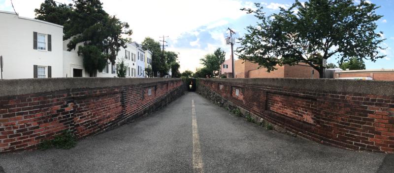
Wilkes Street Tunnel from the western approach, July 2017 — the brick-arched railroad tunnel cut beneath Wilkes Street in the early 1850s for the Orange & Alexandria Railroad to reach the Potomac wharves, today an Old Town pedestrian and bicycle passage. © KingSt.com, July 2017 Wilkes Street (between South Royal and South Lee)
Brick-arched railroad tunnel carved beneath Wilkes Street in the early 1850s for the Orange & Alexandria Railroad to reach the city's …
Placeholder illustration of Interarms Warehouse Complex South Union. Seed placeholder — KingSt.com, 2026. To be replaced with archival photograph. South Union Street
Complex of converted warehouse buildings along South Union Street used by Interarms from the late 1950s to the late 1990s to store surplus …
201 Prince Street 201 Prince Street
Greek Revival temple-front building completed 1851 at 201 Prince Street as the Bank of the Old Dominion. Used during the Civil War as a …
Now
No current occupant on file. Are you, or someone you know, the present occupant? Claim this place to add operating hours, a current photo, and a short note.
Union Street
Named for The federal union of American states, c. 1796.
Interpretive signs nearby
The City of Alexandria has installed 1 historical interpretive sign within walking distance of this place. Each link below opens the sign's page on this site, with the full image and trail context.
W side S. Union at entrance to Windmill Hill Park
Sources
- 1.
City of Alexandria, Department of Recreation, Parks & Cultural Activities, "Windmill Hill Park," alexandriava.gov/parks/location/ windmill-hill-park, accessed 2026. Used here for the park's operating hours (sunrise to sunset), the amenity inventory (basketball, volleyball, playground, picnic, unfenced dog area, walking trail, waterfront, wooded area), and the 2003 City Council-approved long-range plan that called for replacing the Potomac-edge bulkhead with a natural shoreline.
Government record https://www.alexandriava.gov/parks/location/windmill-hill-park →
See something wrong?
Every correction is logged dated to this page. Family history, old photographs, or a citation we missed — everything goes into the file.