
Seminary Hill (off Seminary Road, near St. Stephens Road)
a.k.a. Seminary Hill (off Seminary Road, near St. Stephens Road)
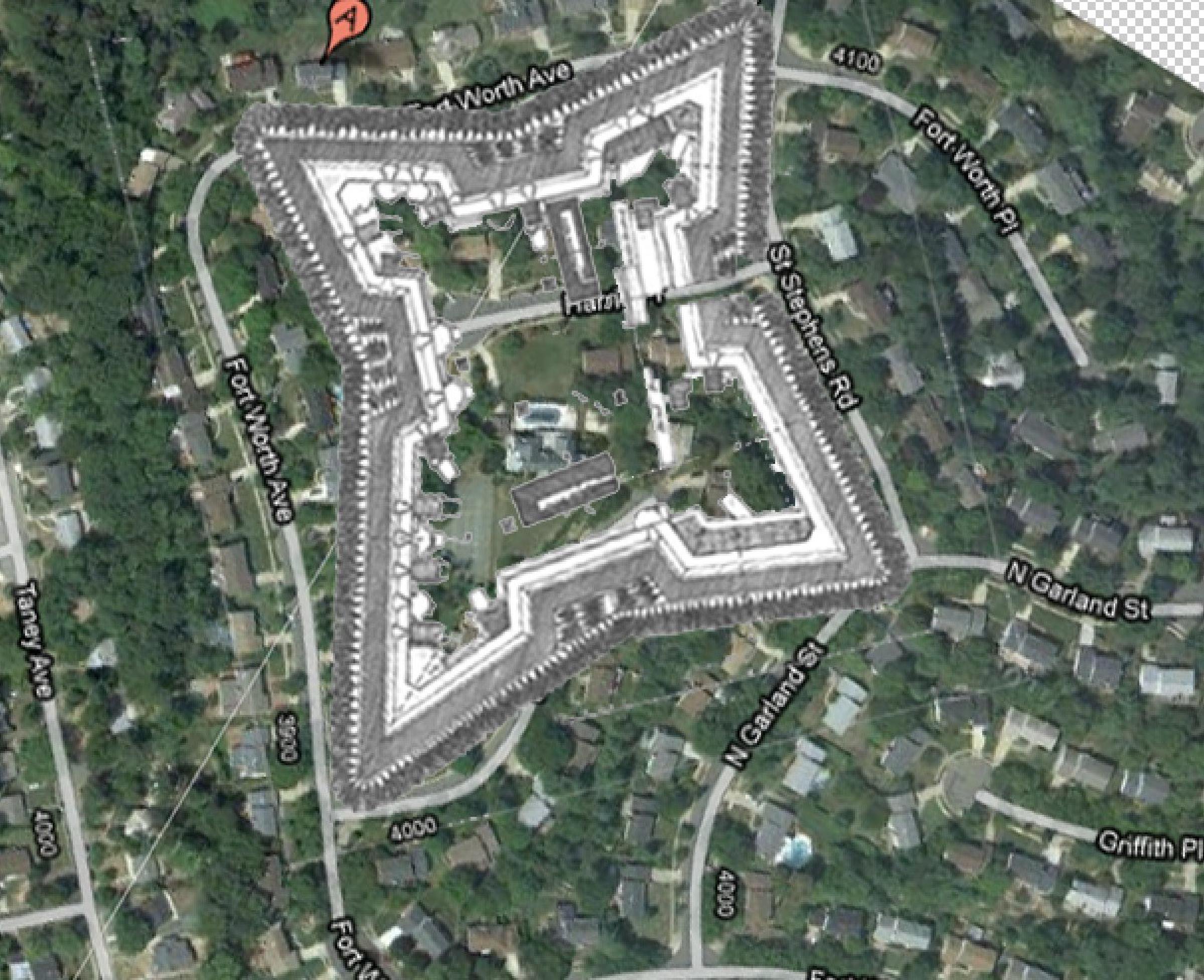
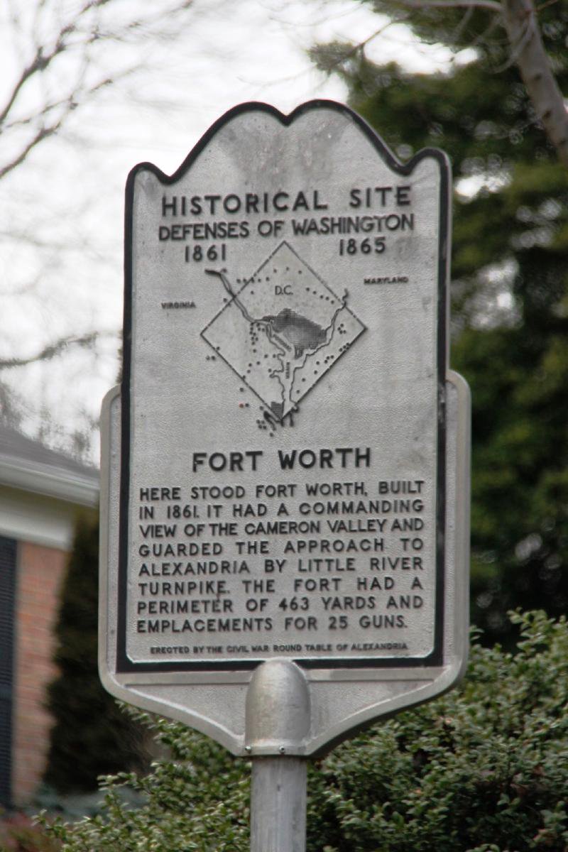
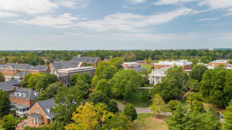
Layered Seminary Hill site that was the country estate “Muckross” of Burke & Herbert Bank co-founder Arthur Herbert, the Civil War earthwork Fort Worth (1861-1865), and finally the 1970 Seminary Ridge subdivision. The historical-marker location is on St. Stephens Road west of North Garland Street; the residential street called Fort Worth Avenue lies nearby and approximates the wartime fort area but does not sit on the actual earthwork footprint.
- 1856
- Italianate (rebuilt over Civil War casemates)
- Demolished demolished 1970
Place narrative
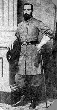
The hilltop south of Old Leesburg Road has been three places. In September 1856 the twenty-seven-year-old banker Arthur Herbert Arthur Herbert b. 1829 · d. 1919 Co-founder of Burke & Herbert Bank (1852), Confederate officer in the 17th Virginia Infantry, and longtime master of "Muckross" on Seminary Hill. Born at Carlyle House; died on the … [1] DAC, 'Arthur Herbert — Muckross,' 2020 Website bought 57¼ acres of the parcel previously called Stump Hill from Elizabeth and Catherine Thompson, paying with one Alexandria home and lot, nine hundred dollars in cash, and three thousand dollars in Orange & Alexandria Railroad bonds (Fairfax County Deed Book Y-3, page 63). Herbert renamed the estate “Muckross” after the Herberts’ ancestral seat in County Kerry, Ireland. The first house was short-lived. After Federal forces occupied Alexandria on May 24, 1861, and in the panicked weeks following the Union defeat at the First Battle of Bull Run, the U.S. Army broke ground on Fort Worth on September 1, 1861, building it partly on the seized Vaucluse plantation tract of the Fairfax family, and in July 1862 demolished the original Muckross house entirely to clear sightlines for the earthwork — a destruction The Southern Churchman reported in its July 1862 pages. Fort Worth was a constituent earthwork of the broader Defenses of Washington [2] LOC, Civil War Defenses of Washington Government record : a 463-yard perimeter with capacity for 25 guns, including one 100-pounder Parrott rifle, two 30-pounder Parrotts, and seven 24-pounder siege guns [3] Wikipedia, "Fort Worth (Virginia)" Website . From one of the highest points west of the city the fort commanded the Orange & Alexandria Railroad, the Little River Turnpike, and the southern approaches to Union-occupied Alexandria, with sightlines down to Cameron Run and Hunting Creek. The first garrison was Col. J. Howard Kitching’s 6th New York Heavy Artillery, which moved up from Fort Albany on Thanksgiving Day, November 27, 1861, and held the post until transferring to Fort Blenker on January 17, 1862. Kitching’s later regimental memoir describes the garrison’s arrival in harsh, unfinished conditions: troops camped in muddy tents outside the earthworks through freezing winter weather, swapping artillery drills for axes and shovels and finishing the construction of the fort themselves [4] J. Howard Kitching, "More than a Conqueror" (1873) Book [3] Wikipedia, "Fort Worth (Virginia)" Website . The Vaucluse tract appears in this record on both ends: the Federal government seized it from the Fairfax family in 1861 to build the fort, and Herbert reacquired thirty-nine acres of the surviving Vaucluse parcel from the family’s heirs in 1877 (see below).
The Silvey episode (1864–1866)
In July 1864 the Federal government seized the Muckross tract under the Confiscation Act and sold it to Maj. William Silvey Maj. William Silvey d. 1875 Union Army major and West Point Class of 1849 graduate; held title to Alexandria's 1864-66 after the Federal government seized it from under the Confiscation Act. Postwar … , a Union Army major then serving as General Superintendent of Volunteer Recruiting, for just one hundred twenty-five dollars. The transfer is a brief, deeply unequal moment in the property’s record: a Confederate officer’s confiscated estate auctioned at a fraction of its prewar value to a Union officer who held the title for less than two years.
On April 8, 1866 — eleven months after Appomattox — Major Silvey and his wife Isabella sold the property back to Herbert for sixteen hundred dollars. Herbert rebuilt across 1866 and 1867, setting the new house partially atop Fort Worth’s powder magazine; the magazine’s solid-masonry casemates served as cellars, a quiet record of the war preserved in the foundations. The visiting memoirist Mrs. Burton Harrison described the postwar hilltop as Herbert returned to it: the crest of the hill bare of dwelling, trees, and fences, with the fort’s casemates the only structures left standing [5] Mrs. Burton Harrison, Recollections Grave and Gay (1911) Book .
Land acquisitions across forty years
Herbert added to the rebuilt estate steadily across the decades that followed — four documented acquisitions across the 1869 to 1901 span growing Muckross from its original 57¼ acres to a final 115.56-acre estate:
- October 1869 — two acres plus an access road from Duke Street (FFX DB K-4, P. 261).
- October 23, 1877 — thirty-nine acres acquired from Vaucluse heirs (FFX DB V-4, P. 349–354); the heirs retained seventy-eight acres of the larger Vaucluse tract.
- May 1895 — three acres along Old Leesburg Road (FFX DB V-5, P. 269); the earlier residence on the parcel served thereafter as the gate house to Muckross.
- November 1901 — fourteen and 83/100 acres from Strawberry Hill Farm (FFX DB I-6, P. 154).
Herbert lived at Muckross with his wife Alice Gregory and their five daughters until his death there on February 23, 1919 [1] DAC, 'Arthur Herbert — Muckross,' 2020 Website .
The estate stayed in family hands through the early twentieth century. The parcel itself was originally Fairfax County land; Alexandria annexed the Seminary Hill area in the 1950s, which is why a Civil War fortification site sits inside the modern city limits today. The tract was finally subdivided in 1970 for Seminary Ridge, a residential development whose street grid preserves the fort’s memory in the residential street name “Fort Worth Avenue” nearby — though the avenue does not lie on the actual earthwork footprint. The Civil War historical marker now sits on St. Stephens Road west of North Garland Street [6] HMDB, Fort Worth historical marker, Alexandria, VA Government record , the closest public record of the hilltop’s wartime role. The powder-magazine cellars are gone; the hilltop’s commanding view of Cameron Run and Hunting Creek — the reason Federal engineers chose it in 1861 — remains.
Among Seminary Ridge children of the 1950s and 1960s the property was known as the “Moss Mansion” — a neighborhood corruption of MUCKROSS engraved in the pillars that flanked the entrance from St. Stephens Road. A reminiscence shared in 2024 on a public Alexandria Facebook page describes the property in its final years before demolition: terraced gardens bordered by ancient boxwoods large enough to climb inside, decaying outbuildings holding dog skeletons (or so the children believed of the rumored “Dr. Moss”), and a water tower in the valley that would become upper Fort Williams Parkway. By the writer’s freshman fall in college the hillside was “totally stripped bare, with nothing but clay and concrete to be seen” [7] Public Facebook reminiscence shared by Michael Guiffre Fannon, 2024 Oral history . The transition from Italianate country house to suburban subdivision had the suddenness of a single season; almost no on-site documentary record of the rebuilt 1867 house survives.
The contemporary residential address 4007 Moss Place, in the post-1970 Seminary Ridge subdivision that replaced the estate, is sometimes marketed under the historic “Muckross” name. No primary-source evidence at the Alexandria Library Special Collections has yet established that the structure currently at 4007 Moss Pl is fabric of the 1856 Herbert house; pending further research, this site treats that address as name-bearing, not house-bearing. [8] Alexandria Library Special Collections Manuscript
Timeline
10 chronological entries across 5 eras.
- –
Arthur Herbert acquires 57¼ acres and builds Muckross [1] Source DAC, 'Arthur Herbert — Muckross,' 2020
- –
Herbert lives at Muckross with wife Alice Gregory and five daughters [1] Source DAC, 'Arthur Herbert — Muckross,' 2020
Original Muckross house completed [1] Source DAC, 'Arthur Herbert — Muckross,' 2020
- –
Union Army builds Fort Worth, demolishing the original 1856 house for sightlines [1] Source DAC, 'Arthur Herbert — Muckross,' 2020 [2] Source LOC, Civil War Defenses of Washington
Fort Worth construction begins on the Muckross hilltop [3] Source Wikipedia, "Fort Worth (Virginia)" [2] Source LOC, Civil War Defenses of Washington
Original house torn down for Fort Worth [1] Source DAC, 'Arthur Herbert — Muckross,' 2020
- –
Union Major William Silvey holds confiscation-sale title to Muckross 1864-66, repurchased by Herbert April 1866 [1] Source DAC, 'Arthur Herbert — Muckross,' 2020
Muckross rebuilt over the fort's powder magazine [1] Source DAC, 'Arthur Herbert — Muckross,' 2020
Arthur Herbert dies at Muckross, age 89 [1] Source DAC, 'Arthur Herbert — Muckross,' 2020
The building
- Italianate (rebuilt over Civil War casemates)
Gallery

Civil War Round Table of Alexandria historical marker for Fort Worth, on St. Stephens Road west of North Garland Street. © KingSt.com, 2026 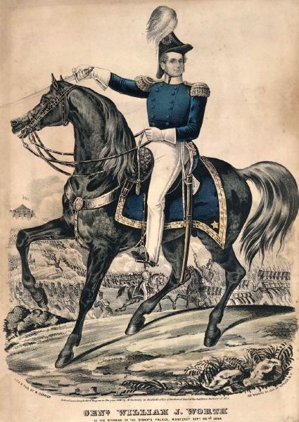
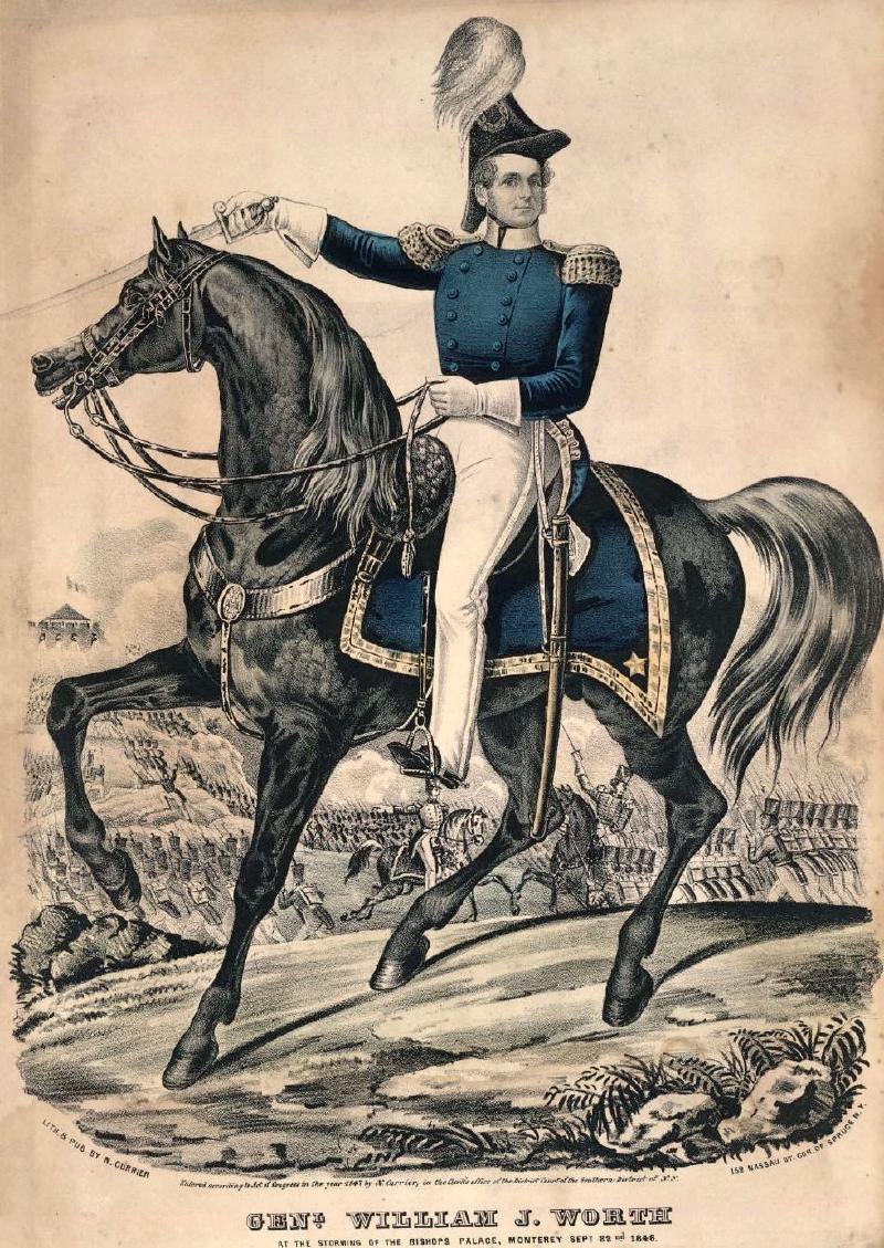
General William Jenkins Worth (1794–1849), the fort's namesake — a hero of the Mexican-American War who died of cholera in San Antonio two years before the war for which the fort was named began. Portrait of Gen. William Jenkins Worth, c. 1849 (public domain by age) 
Col. Arthur Herbert — banker, Confederate officer, and the postwar rebuilder of Muckross over Fort Worth's powder-magazine cellars. Portrait of Col. Arthur Herbert (public domain by age)

Historical maps and documents
Fort Worth engineering plan, traced from the Office of the Chief Engineer, Defenses of Washington — January 1864. Plan view, sectional profiles, and armament cartouche on a single sheet. U.S. Army Office of the Chief Engineer, Defenses of Washington — January 1864 (public domain by age) · drag to pan, scroll to zoom Fort Worth plan with full armament inventory, 1864 — including two 100-pounder Parrott rifles, two 30-pounders, one 10-pounder, and seven 24-pounder siege guns. U.S. Army Office of the Chief Engineer, Defenses of Washington — 1864, Drawer 170, Sheet 169 (public domain by age) · drag to pan, scroll to zoom
Connected
Arthur Herbert
b. 1829 · d. 1919
Co-founder of Burke & Herbert Bank (1852), Confederate officer in the 17th Virginia Infantry, and longtime master of "Muckross" on Seminary Hill. Born at Carlyle House; died on the …
Owner · Residence · %!d(float64=1856)–%!d(float64=1919)
U.S. Army (Civil War)
founded 1775
The Federal land army that occupied Alexandria from May 24, 1861 through 1865 and constructed the Defenses of Washington, including and . Used as a collective entity here for …
Operator · Military · %!d(float64=1861)–%!d(float64=1865)
Maj. William Silvey
d. 1875
Union Army major and West Point Class of 1849 graduate; held title to Alexandria's 1864-66 after the Federal government seized it from under the Confiscation Act. Postwar …
Owner · Residence · %!d(float64=1864)–%!d(float64=1866)
Nearby in time
Placeholder illustration of Louverture Hospital Site. Seed placeholder — KingSt.com, 2026. To be replaced with archival photograph. 219 South Payne Street
Union Army hospital established in February 1864 for U.S. Colored Troops and Black civilian refugees in occupied Alexandria. Named for …
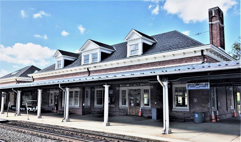
Beyond My Ken · via Wikimedia Commons · CC BY-SA 4.0 110 Callahan Drive
1905 railway terminal at the foot of King Street, currently serving Amtrak, VRE, and Washington Metro Blue/Yellow lines. NRHP-listed 2013.
712 Prince Street 712 Prince Street
Federal-style 1820s townhouse later occupied by mayor and judge Henry Daingerfield's family. NRHP-listed 2019.
814 Duke Street 814 Duke Street
Townhouse associated with Dr. Albert Johnson, a 19th-century African-American physician in Alexandria. NRHP-listed 2004.
Nearby in space
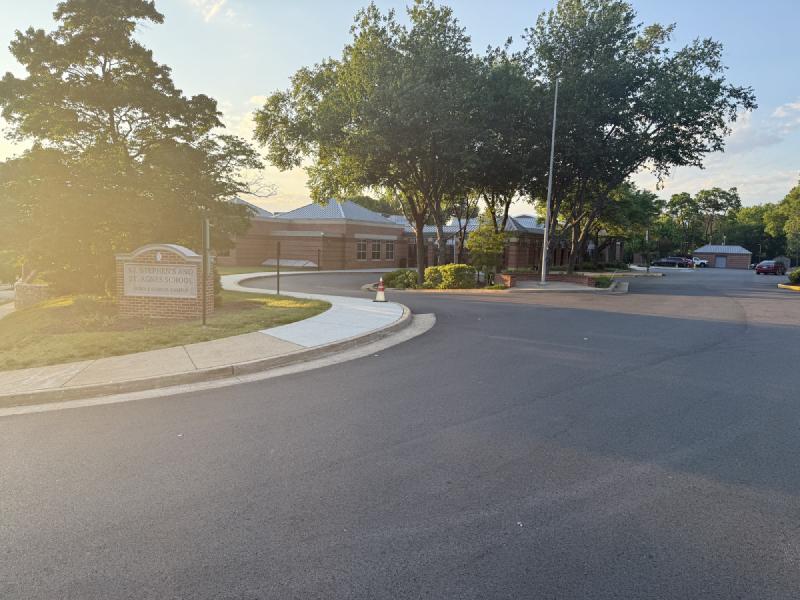
St. Stephen's and St. Agnes Middle School Campus on West Braddock Road at sunrise — the entrance sign and the brick academic buildings beyond, back-lit by golden-hour light. © KingSt.com, 2024 4401 West Braddock Road
Middle School (grades 6–8) of St. Stephen's & St. Agnes since the late 1990s, on the West Braddock Road campus that previously housed …
1000 Saint Stephens Road 1000 Saint Stephens Road
Upper School (grades 9–12) of St. Stephen's & St. Agnes School, occupying the Saint Stephens Road campus opened in January 1957 by St. …
Episcopal High School's 100-acre campus from above, September 2019 — Hoxton House (white columns, right) anchors the south end; the Collegiate Gothic academic buildings ring the central quad. Aerial view of Episcopal High School, by Penguino2020 / Wikimedia Commons, CC BY-SA 4.0 (2019) 1200 North Quaker Lane
The first high school in Virginia, founded 1839 by Bishop William Meade of the Episcopal Diocese on a 100-acre campus west of Old Town. …
Jerrye & Roy Klotz, MD · via Wikimedia Commons · CC BY-SA 3.0 510 North Quaker Lane
Mid-century modern residence designed by architect Charles M. Goodman, who pioneered modernist housing in the Washington region. NRHP-listed …
Now
No current occupant on file. Are you, or someone you know, the present occupant? Claim this place to add operating hours, a current photo, and a short note.
Interpretive signs nearby
The City of Alexandria has installed 1 historical interpretive sign within walking distance of this place. Each link below opens the sign's page on this site, with the full image and trail context.
Fort Worth — Defenses of Washington (1861-1865)
806 St Stephens Road, Alexandria, VA — on St Stephens Road west of North Garland Street
Sources
- 1.
D.A.C.A.V.A.L., "Arthur Herbert — Muckross," Seminary Hill / Alexandria research blog, October 13, 2020.
Website https://dacavalx.wordpress.com/2020/10/13/arthur-herbert-muckross/ →
- 2.
Library of Congress, "Civil War Defenses of Washington," Prints & Photographs Division, including HABS HABS DC,WASH,652- documentation of the fort ring around Washington of which Fort Worth was a constituent earthwork.
Government record https://www.loc.gov/pictures/search/?q=Defenses+of+Washington →
- 3.
Wikipedia contributors, "Fort Worth (Virginia)," Wikipedia, The Free Encyclopedia, accessed 2026. Cites the Official Records of the Union and Confederate Armies; J. Howard Kitching, "More than a Conqueror" (1873); the National Park Service Civil War Defences of Washington chronology; and primary engineering plans for the fort. Used here for the September 1, 1861 construction date, the 463-yard perimeter, the 25-gun capacity, the 100-pounder Parrott armament, and the November 1861–January 1862 garrison by Col. J. Howard Kitching's 6th New York Heavy Artillery.
Website https://en.wikipedia.org/wiki/Fort_Worth_(Virginia) →
- 4.
J. Howard Kitching, "More than a Conqueror; or, Memorials of Col. J. Howard Kitching, Sixth New York Artillery," New York: Robert Carter & Brothers, 1873. Regimental memoir compiled posthumously from Kitching's letters and journals. Used here for the garrison's Thanksgiving Day arrival at Fort Worth on November 27, 1861, and the description of troops camped in muddy tents outside the unfinished earthworks through freezing winter weather, swapping artillery drills for axes and shovels to finish building the fort themselves.
- 5.
Mrs. Burton Harrison (Constance Cary Harrison), Recollections Grave and Gay, New York: Charles Scribner's Sons, 1911. Memoir; the Muckross passage describes Arthur Herbert's return to the postwar hilltop.
Book
- 6.
Historical Marker Database, "Fort Worth," entry for the Alexandria, Virginia historical marker, located on St. Stephens Road west of North Garland Street, accessed 2026.
Government record https://www.hmdb.org/m.asp?m=80466 →
- 7.
Public Facebook reminiscence on the Alexandria, Virginia community page, shared by Michael Guiffre Fannon and authored by an anonymous Seminary Ridge childhood-era resident. Describes the Muckross/"Moss Mansion" property in its final years before the 1970 Seminary Ridge subdivision: pillars engraved MUCKROSS at the entrance from St. Stephens Road, terraced gardens with ancient boxwoods, decaying outbuildings, and the water tower in the valley that became upper Fort Williams Parkway. Used here as oral-history evidence of the property's late-period appearance and neighborhood reception.
Oral history
- 8.
Alexandria Library, Local History/Special Collections, Barrett Branch, Alexandria, Virginia.
Manuscript
See something wrong?
Every correction is logged dated to this page. Family history, old photographs, or a citation we missed — everything goes into the file.